

Terrain, Elevation, and Landforms
Mountains, uplands, plains, terraces, ridges, and lowlands.
Caerlon is a continent of connected watersheds, difficult crossings, and regions shaped by what the land allows. The Valen, Torin, and Greenmantle drain toward the Sunset Gulf in the west and southwest. The Esten flows east through the Heart Plains, Harrow Gap, and the Scoured Marches before reaching the Dread Sea at Estenwatch.
The Silveredge Arc divides the western river systems from the Esten watershed. West of the range lie Highharbor, the Crownward Uplands, the Elderidge Hills, the Torin Bridgeholds, and the Verdant Terraces. East of it lie the upper Esten, Heart Plains, Harrowline Ridge, and the invasion-scarred country descending toward the Dread Sea. High Silver Gate is the principal continent-scale passage between the western river systems and the Esten watershed.
The physical atlas shows the land beneath Caerlon’s roads, borders, settlements, and institutions. Later maps add those layers without changing the accepted coastline, terrain, rivers, or numbered locations.

The numbered physical atlas shows Caerlon’s coastline, major terrain, rivers, gateways, settlements, fortresses, and crossing points. Roads, political borders, military jurisdictions, and changing Marcher conditions are not shown. This is a relative-position atlas and is not drawn to a fixed measured scale.
Open the semantic atlas · Open the raster atlas · Read the atlas text description · Read the detailed map and spatial orientation
Caerlon has two opposing maritime faces. The western side opens toward the Sunset Gulf and the wider routes toward Marithel. Highharbor occupies the Valen estuary and serves as the principal western deepwater gateway. The eastern side faces the Dread Sea, the Broken Chain approaches, and Vorrak beyond them. Estenwatch stands at the mouth of the Esten and controls the principal eastern river entrance.
Between those coasts, the land rises from western river country to the Silveredge Arc, opens into the Heart Plains, rises again at Harrowline Ridge, and then descends through the Scoured Marches to the Dread Sea. The diagram below is an orientation aid rather than a measured elevation profile, distance scale, or travel-time diagram.
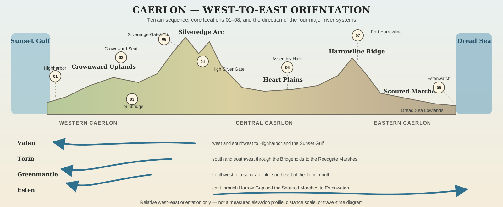
Western Caerlon contains the principal Sunset Gulf approaches and three westward river systems. The Valen reaches Highharbor after passing the Crownward heartlands. The Torin runs through a sequence of independent Bridgeholds before entering the Reedgate Marshes south of Highharbor. The Greenmantle crosses the Verdant Terraces and reaches a separate sheltered inlet southeast of the Torin mouth.
Ports, river communities, cultivated uplands, bridge jurisdictions, surviving archives, and old administrative roads give western Caerlon several centers rather than one capital.
Central Caerlon is organized around the Silveredge Arc, High Silver Gate, and the Heart Plains. The range divides the western river systems from the east-flowing Esten. Silveredge Gatehold stands on the higher western approach to the principal pass.
East of the mountains, the Heart Plains spread between the Esten and Torin basins. Their fields, mills, storage settlements, and assembly sites make them essential to food supply and overland movement. The Heartplain Assembly Halls stand on dry ground at Assembly Ridge rather than on a riverbank.
Eastern Caerlon changes at Harrowline Ridge, where the Esten passes through Harrow Gap beneath Fort Harrowline. Beyond the ridge lie the Scoured Marches: rebuilt settlements, working fields, ruined estates, abandoned ground, and routes whose condition may differ from one season or report to the next.
The lower Esten continues to Estenwatch and the Dread Sea. The coast faces the Broken Chain, the route by which the invasion from Vorrak reached Caerlon.
Mountains, uplands, plains, terraces, ridges, and lowlands.
Four major rivers, drainage basins, tributaries, wetlands, and river mouths.
Weather movement, seasonal patterns, floods, storms, snow, and growing seasons.
Region placement, neighboring regions, boundaries, and transition zones.
Major maritime faces, river mouths, mountain gate, and continental approaches.
Concrete road, river, pass, ferry, and maritime route geometry and travel times.
Numbered atlas locations and continent-scale settlement hierarchy.
Dated public geography and condition categories of the eastern Marches.
Caerlon’s regions are not all clean administrative provinces. Some follow river systems or mountain terrain. Others are recognized through settlement patterns, local identity, war history, or the authority that can keep a crossing, market, road, or refuge functioning.
| Region | Position and character |
|---|---|
| Highharbor Coast | The western Valen estuary and surrounding Sunset Gulf coast; Caerlon’s principal western maritime entrance. |
| Valenic Compact | The upper and middle Valen; river towns, mills, ferries, and linked valley communities. |
| Crownward Remnant | Western-central uplands south of the middle Valen; old administrative centers, records, and restored roads. |
| Elderidge Oathlands | Broken western hill country between the Valen, Torin, and Greenmantle basins. |
| Torin Freeholds | The Torin valley and its ordered sequence of independent Bridgeholds. |
| Verdant Principalities | Southwestern terraces, estates, orchards, canals, and the Greenmantle valley. |
| Region | Position and character |
|---|---|
| Silveredge Holds | Mountain settlements, mines, passes, signal sites, and fortified ledges along the watershed divide. |
| Heart Plains | The broad central agricultural basin east of Silveredge, mainly south of the Esten. |
| Estenmark | The upper and middle Esten corridor between Silveredge and Harrowline. |
| Region | Position and character |
|---|---|
| Scoured Marches | Eastern Caerlon from Harrowline toward the Dread Sea; rebuilt, contested, and damaged country. |
| Broken Chain Approaches | The eastern coast and offshore waters facing the Broken Chain. |
The Dread Sea Coast is a physical coastline rather than a twelfth region. Its settlements and waters are treated principally through the Scoured Marches and Broken Chain Approaches.
Controlling continental coastline, terrain, rivers, and numbered locations.
Continuous sectional diagram showing terrain sequence, core sites 01–08, and drainage direction.
The detailed orientation page explains the atlas key, the four major rivers, the sixteen numbered locations, and the fixed relationships among Caerlon’s regions and gateways.
