Appearance
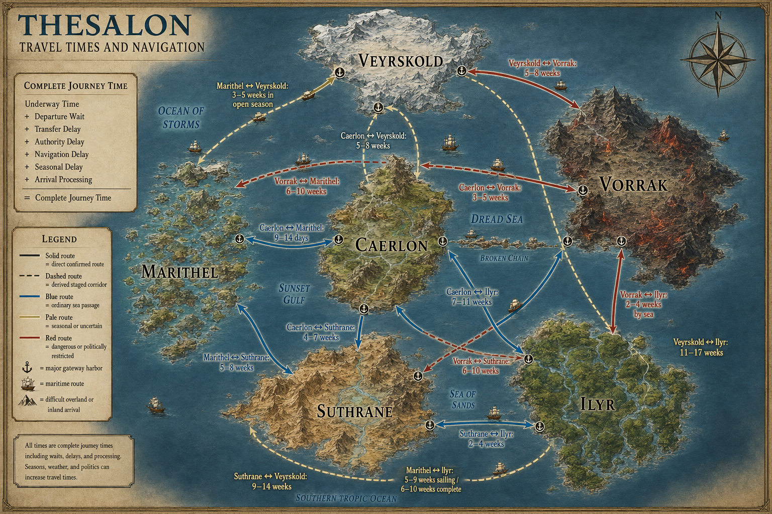
Travel Times and Navigation
A journey in Thesalon is not measured by distance alone.
Travel time includes the hours spent moving, but also the time required to obtain a vessel or guide, wait for a departure window, transfer cargo, clear inspection, correct a route, respond to weather, and enter the destination legally.
The world map shows ordinary gateway-to-gateway complete journey bands. Solid routes are directly supported by established route canon. Dashed routes are derived staged corridors built from the authoritative continental arrangement and confirmed neighboring routes. Inland travel after arrival is additional.
The Complete Journey
text
UNDERWAY TIME
+ DEPARTURE WAIT
+ TRANSFER DELAY
+ AUTHORITY DELAY
+ NAVIGATION DELAY
+ SEASONAL DELAY
+ ARRIVAL PROCESSING
= COMPLETE JOURNEY TIME
Underway Time
Underway time is the time required to cover the route using the current transport profile.
It depends on:
- distance;
- traveler, vehicle, or vessel profile;
- effective operating hours;
- terrain;
- wind and current;
- route state;
- damage;
- propulsion;
- required pilotage;
- whether movement continues overnight.
Operational Delay
Operational delay is not an abstraction to be hidden inside the vessel’s speed.
A traveler may spend ten hours underway and two days waiting for a convoy. A river boat may cover the physical distance quickly but lose a day at a closed lock. A vessel may reach Ilyr’s coast and still require quarantine, guide assignment, and a controlled inland transfer.
The route record should state why a delay exists and what the travelers can do about it.
Standard Intercontinental Travel Matrix
The following table gives ordinary complete journey ranges between the principal international gateways of every continent.
| From / To | Caerlon | Vorrak | Suthrane | Veyrskold | Marithel | Ilyr |
|---|---|---|---|---|---|---|
| Caerlon | — | 3–5 weeks | 4–7 weeks | 5–8 weeks | 9–14 days | 7–11 weeks |
| Vorrak | 3–5 weeks | — | 6–10 weeks | 5–8 weeks | 6–10 weeks | 2–4 weeks by sea |
| Suthrane | 4–7 weeks | 6–10 weeks | — | 9–14 weeks | 5–8 weeks | 2–4 weeks |
| Veyrskold | 5–8 weeks | 5–8 weeks | 9–14 weeks | — | 3–5 weeks in open season | 11–17 weeks |
| Marithel | 9–14 days | 6–10 weeks | 5–8 weeks | 3–5 weeks in open season | — | 5–9 weeks sailing; 6–10 weeks complete |
| Ilyr | 7–11 weeks | 2–4 weeks by sea | 2–4 weeks | 11–17 weeks | 5–9 weeks sailing; 6–10 weeks complete | — |
The matrix is symmetric as a planning baseline. Actual directional travel can differ because prevailing wind, current, convoy scheduling, river flow, war, law, quarantine, and seasonal closure do not affect both directions equally.
Confirmed and Derived Routes
Nine intercontinental pairs have direct source-backed route definitions.
Six pairs currently use derived staged routes built from confirmed neighboring corridors:
- Caerlon–Ilyr;
- Vorrak–Suthrane;
- Vorrak–Veyrskold;
- Vorrak–Marithel;
- Suthrane–Veyrskold;
- Veyrskold–Ilyr.
These derived bands are usable for campaign planning. Their exact gateway positions and charted distances should be validated when the final world route map is locked.
Marithel and Ilyr
Ilyr is farther from Marithel than Caerlon and requires a more difficult arrival procedure.
Use:
| Passage condition | Time |
|---|---|
| Fast underway passage | 3–4 weeks |
| Ordinary sailing passage | 5–9 weeks |
| Ordinary complete journey | 6–10 weeks |
| Slow cargo or disrupted passage | 2–3 months |
The older 3–5 week standard estimate should not be used as the ordinary complete journey.
Rules Sources and Scale
The travel system uses several rule layers without treating them as interchangeable.
| Scale | Governing procedure | Typical duration |
|---|---|---|
| World and regional journey | PF2e exploration travel, World Seasons, route registry, and complete-journey delays | Hours, days, or weeks |
| Naval chase | High Seas and the GM Core chase subsystem | Minutes, hours, or days |
| Sailing combat | High Seas mode structure with the selected Smoke & Sail advanced overlay | One-minute rounds |
| Boarding combat | Ordinary PF2e Remaster encounters | Six-second rounds |
| Underwater exploration | PF2e aquatic movement plus route and environmental rules | Minutes or hours |
Tactical vessel movement is never multiplied across a day to create world travel speed.
Pathfinder 2e Remaster Baseline
For creatures, PF2e exploration travel uses Speed to determine feet per minute, miles per hour, and miles per day.
| Speed | Miles per hour | Miles per ordinary travel day |
|---|---|---|
| 15 feet | 1.5 | 12 |
| 20 feet | 2 | 16 |
| 25 feet | 2.5 | 20 |
| 30 feet | 3 | 24 |
| 35 feet | 3.5 | 28 |
| 40 feet | 4 | 32 |
Difficult terrain halves progress. Greater difficult terrain reduces progress to one-third.
Many exploration activities reduce a traveler to half Speed. A group that is actively Avoiding Notice, Defending, Detecting Magic, or Searching may therefore cover less ground than a group performing steady travel.
Vehicles
Vehicle Speed supplies the mechanical exploration baseline, but the complete journey also records:
- propulsion;
- operating hours;
- crew and watch coverage;
- route restrictions;
- weather;
- repairs;
- transfer and authority delay.
Routine travel on a safe known corridor does not require repeated Drive or piloting checks. Checks occur when a hazardous maneuver, route problem, environmental event, or uncertain approach makes the result meaningful.
Calibrated Maritime Profiles
Thesalon uses nautical miles for sea routes. One knot equals one nautical mile per hour.
| Profile | Nominal speed | Effective progress hours/day | Ordinary daily progress |
|---|---|---|---|
| Inter-island local craft | 4.5 knots | 18 | About 81 nautical miles |
| Reef and shoal pilot craft | 3.75 knots | 12 | About 45 nautical miles, before pilot or tide delay |
| Coastal merchant | 4 knots | 20 | About 80 nautical miles |
| Ocean-going merchant | 3.75 knots | 24 | About 90 nautical miles |
| Slow organized convoy | 1.8 knots | 20 | About 36 nautical miles |
| Cold-water open-season passage | 2.5 knots | 24 | About 60 nautical miles |
| Cold-water near-closure passage | 1.5 knots | 20 | About 30 nautical miles |
| Fast cutter or packet | 6 knots | Up to 24 | About 144 nautical miles before route caps |
Effective progress hours are not the number of hours one person works without rest. They represent the hours during which the vessel makes route progress under its crew and watch system.
Operating Limits
- Ocean vessels require sufficient crew for full watch coverage before using a 24-hour profile.
- Local craft normally stop or reduce operation for darkness, harbor closure, crew limits, or short-route service patterns.
- Reef routes are limited by pilot, light, beacon, and tide windows.
- Convoys lose effective progress to spacing, signaling, regrouping, and the slowest required vessel.
- Ice-edge travel loses progress to lookout duty, route verification, shelter, and repeated reports.
- A final vessel stat block may override a profile, but the route must then be recalibrated against canonical travel-time anchors.
Wind, Current, and Weather
World Seasons determines the ordinary daily weather pattern. The maritime rules translate that result into a route effect.
Calibrated Wind Bands
| Condition | Journey-scale treatment |
|---|---|
| Neutral | Use nominal profile speed |
| Ordinary favorable wind or current | Increase effective speed by 25%, up to the profile or route cap |
| Ordinary adverse wind or current | Reduce effective speed by 25%, not below the profile slow band |
| Strong favorable event | Increase by up to 50%, never more than 2 knots and never above the cap |
| Strong adverse event | Reduce by up to 50%, never more than 2 knots and never below the slow band |
| Doldrums | Wind-only sail progress becomes 0; use oars, tow, current, magic, or wait |
| Extreme weather | Ordinary travel is closed unless a specific protected or magical exception exists |
The direct Smoke & Sail ±2 Speed effect is retained as a ceiling for a strong event rather than the default daily modifier. At common 3–5 knot vessel speeds, applying ±2 knots every ordinary day would produce changes too large for the established route ranges.
High Seas’ guidance to use one major weather complication at a time is retained. A storm may change progress, visibility, route state, or transfer access. It does not need to impose every possible penalty simultaneously.
Damage
A broken vehicle or vessel has reduced Speed under the applicable vehicle rules. Damage can also reduce operating hours, force a transfer, require repair, or close routes that demand a minimum handling capability.
Navigation Dependency
Navigation is not a universal daily roll. It is a dependency recorded on the route.
| Class | Name | Ordinary meaning |
|---|---|---|
| N0 | Self-evident | Maintained road, obvious crossing, or visible local corridor |
| N1 | Charted | Signs, charts, markers, buoys, landmarks, or public instructions exist |
| N2 | Specialist advised | Independent travel is allowed, but expert help materially improves reliability |
| N3 | Specialist required | A recognized pilot, guide, steward, or equivalent specialist is normally required |
| N4 | Restricted or hidden | Access knowledge, sponsorship, authority, or secrecy is required |
| N5 | Conditional or planar | Tide, ritual, dream, beacon state, thin place, or another activation condition controls the route |
Skills
Thesalon adopts Smoke & Sail’s Navigation concept without removing official skills.
| Task | Preferred or recognized checks |
|---|---|
| Long-distance charting | Navigation, Sailing Lore, or relevant regional Lore |
| Ordinary ship operation | Navigation or Sailing Lore |
| Wind-powered steering | Navigation, Sailing Lore, or Nature when the task is specifically steering by wind |
| Reef or shoal approach | Navigation, Sailing Lore, or recognized local Pilot Lore |
| Severe weather | Navigation, Sailing Lore, Nature, Survival, or an established regional substitute |
| Naval chase obstacle | The skill listed for the obstacle; Sailing Lore and Navigation are broadly applicable |
| Forecasting | Survival, Weather Lore, regional tradition, or an established campaign practice |
A character who receives Sailing Lore from an official option keeps it. They are not required to replace it with Navigation.
Celestial Navigation
The selected Smoke & Sail long-distance navigation benefit is retained as a campaign option.
A qualified navigator can increase the vessel’s listed long-distance speed according to proficiency when celestial references—or an equivalent Thesalon system—are available.
The bonus cannot override:
- convoy pace;
- compulsory pilotage;
- reef-safe speed;
- damaged-vessel Speed;
- route closure;
- extreme weather;
- a lower profile or legal speed cap.
When to Roll Navigation
Do not roll repeatedly on a safe, known, current route.
Roll when one of the following becomes true:
- The route report is missing, stale, or contradictory.
- A required pilot, guide, chart, beacon response, sponsor, or legal condition is absent.
- Weather, tide, current, ice, visibility, flood, or living terrain materially changes.
- The travelers enter a hazardous leg such as a reef cut, major pass, shoal, hidden channel, or conditional route.
- The group attempts a shortcut, night approach, forced passage, or unauthorized entry.
- A pursuit or encounter changes the applicable travel mode.
Navigation Consequences
Failure should usually change time, information, position, access, or route state before it automatically causes damage.
| Outcome | Common consequence |
|---|---|
| Critical success | Use the favorable band, reduce delay, reveal a secondary route, or identify a developing hazard early |
| Success | Use the expected route and time band |
| Failure | Add several hours, miss a window, reach an alternate landing, or require a safer approach |
| Critical failure | Wrong approach, one-day delay, route failure, lost legal access, grounding risk, or an emergency scene |
Damage occurs when the actual hazard supports it.
Delay Categories
| Delay | Common range | Examples |
|---|---|---|
| On-demand departure | 0–2 hours | Local ferry, harbor craft, available animals |
| Scheduled ferry or packet | 0–8 hours | Missed departure, fixed route cycle |
| Daily or irregular ship | 0–24 hours | Berth, crew, cargo, or tide availability |
| Convoy assembly | 1–3 days | Protected merchant, refugee, or military movement |
| Simple transfer | 1–4 hours | Passengers, light cargo, animal exchange |
| Major transfer | 4–12 hours | Warehouses, vessel change, river–sea handling |
| Routine inspection | 1–6 hours | Customs, registry, cargo, identity, or gate procedure |
| Quarantine or legal hold | 1–7 days | Health, cargo, investigation, or disputed authority |
| Minor navigation deviation | 1–4 hours | Corrected course or missed landmark |
| Missed route window | 6–24 hours | Tide, lock, ferry, convoy, or pilot opening |
| Wrong approach | 12–24 hours | Backtracking or arrival at another node |
| Routine arrival processing | 1–6 hours | Docking, inspection, final transfer, guide assignment |
Some delays overlap. Cargo can be inspected while a ship waits for tide. Other delays do not overlap: a vessel held in quarantine cannot use the same hours as underway travel.
Route States and Time
| World Seasons route state | Time treatment |
|---|---|
| Preferred | Use the fast or lower standard band |
| Open | Use the standard band |
| Restricted | Increase underway time by about 25–50% or reduce operating hours |
| Guided or convoy only | Add specialist or departure wait and use the applicable profile |
| Transformed | Replace the transport mode rather than stacking a generic penalty |
| Temporary | Use the temporary route’s own profile |
| Closed | No ordinary travel estimate |
| Unknown | Obtain current information before presenting a dependable range |
Caerlon
Caerlon’s ordinary travel calculations emphasize roads, river corridors, bridges, reconstruction, and the difference between the maintained west and damaged east.
- Heartplain movement normally begins with the PF2e travel table.
- Rivers can carry people and bulk cargo faster than damaged roads.
- Bridge or road damage is recorded as delay, transfer, or route-state change.
- The Scoured Marches commonly move from N1 into N2 or N3.
- Highharbor is the fastest major intercontinental connection in the current world matrix.
Vorrak
Vorrak separates physical movement from permission.
A route may be open in terrain terms while remaining unavailable without a host, escort, tribute procedure, recognized guest-right, or military permission.
- Blackwood routes require local recognition and may not behave like fixed roads.
- Grimspine crossings depend on pass and weather windows.
- Red Waste travel depends on water stages and carrying capacity.
- Covert sea routes are not used as public standard times.
- Authority delay remains separate from underway time.
Suthrane
Suthrane’s travel system is measured by water.
- Upstream and downstream river times must be recorded separately.
- Flood can improve boat movement while closing land routes.
- Locks, ferries, temple procedures, and river–sea transfer add time.
- Desert corridors are determined by water stages, not straight-line distance.
- The Sacred Water Route to Marithel is a mixed river and sea journey rather than continuous open-water sailing.
Veyrskold
Veyrskold has the largest ordinary seasonal variance.
- Stable ice can create temporary roads faster than summer routes.
- Black thaw can be slower and more dangerous than deep winter.
- Fjord routes require current reports, pilots, and sound conditions.
- Cold-water voyages depend on lookout duty, shelter, and repeated route verification.
- The Ropefall–Stormrim route expands from 3–5 weeks in open season to 6–10 weeks near ice closure.
Marithel
Marithel is the primary calibration region for maritime travel.
Established exact anchors include:
| Route | Distance | Canonical time |
|---|---|---|
| Windrider–Sand Island | 18 nautical miles | 3–6 hours |
| Convoy Bell–Gate of Wind and Law | 20 nautical miles | 4–8 hours underway |
| Windrider–Lanternhold | 25 nautical miles | 4–8 hours |
| Windrider–Galeport | 35 nautical miles | 6–12 hours |
| Coinmast–Windrider | 45 nautical miles | 8–14 hours |
| Windrider–Lawkeel | 50 nautical miles | 10–18 hours |
| Wreckscale–Reefcourt | 60 nautical miles | 1–2 days |
| Windrider–Grainwake | 110 nautical miles | 1–2 days |
| Caerlon Sea Road | 900 nautical miles | 9–14 days; 3–4 weeks in slow convoy |
| Ropefall–Stormrim | 1,600 nautical miles | 3–5 weeks open; 6–10 weeks near closure |
All calibrated maritime profiles were validated against these anchors without rewriting the canonical route ranges.
Ilyr
Ilyr’s routes are not merely cleared lines through terrain.
Travel depends on:
- river state;
- living paths;
- wetland depth;
- stewards;
- ecological permission;
- quarantine;
- guide assignment;
- migration and burn periods.
The Green Coast is the primary controlled foreign gateway. Intercontinental arrival time does not include all inland travel through the river, wetland, plateau, or canopy systems.
Calculating a Journey
Step 1: Select the Route
Record:
- origin and destination;
- route ID;
- distance;
- current route state;
- navigation class;
- mode and profile;
- required transfers;
- required authorities;
- known alternatives.
Step 2: Determine Underway Time
For maritime routes:
text
daily progress = effective knots × effective progress hoursFor creature travel, use the PF2e exploration table and terrain multiplier.
For rivers, roads, ice, desert, wetland, and living routes, use the applicable regional profile rather than borrowing an unrelated maritime rate.
Step 3: Apply One Current Environmental Effect
Use World Seasons and current route information.
Select the primary effect:
- speed band;
- operating hours;
- navigation requirement;
- transfer access;
- route-state change;
- closure.
Do not automatically stack all of them.
Step 4: Add Operational Delay
Add departure, transfer, authority, navigation, and arrival delay that does not overlap.
Step 5: Present a Range
Every canonical route should provide:
| Range | Meaning |
|---|---|
| Fast passage | Favorable conditions and minimal ordinary delay |
| Standard passage | The usual player-facing planning range |
| Delayed passage | Common bad conditions, congestion, inspection, or missed transfer |
| Closure threshold | The condition under which no dependable arrival estimate exists |
Example: Highharbor to Windrider
The Caerlon Sea Road is about 900 nautical miles.
An ocean-going merchant uses continuous watches and a calibrated passage band. Route handling, departure, and arrival procedures are part of the canonical range.
- Fast: approximately 6–9 days
- Standard: 9–14 days
- Slow convoy: 3–4 weeks
- Closed or unknown: major storm closure, quarantine suspension, or military interruption
Example: Marithel to Ilyr
The Ilyr Medicine Route is about 2,500 nautical miles and ends at a controlled living-coast gateway.
- Fast underway: 3–4 weeks
- Standard sailing: 5–9 weeks
- Complete journey: 6–10 weeks
- Slow or disrupted: 2–3 months
The complete journey is longer than the sea crossing because ordinary entry can include quarantine, guide assignment, and inland transfer.
Example: Veyrskold to Ilyr
The standard route is a very long staged corridor through eastern waters and the Vorrak–Ilyr connection.
- Fast: 7–10 weeks
- Standard: 11–17 weeks
- Slow: 5–7 months
Different legs can experience northern ice and southern tropical weather during the same journey.
Player-Facing Route Format
A route entry should be readable without consulting the entire rules system.
text
HIGHHARBOR TO WINDRIDER

Standard time: 9–14 days
Fast passage: 6–9 days
Slow convoy: 3–4 weeks
Mode: Ocean-going vessel
Navigation: N1 charted; N2 during severe weather
Departure: Regular merchant and convoy service
Primary delays: Sunset Gulf weather, convoy release, inspection
Closure: Major storm, quarantine suspension, military interruption
Database Record Requirements
Every route should record:
- route ID;
- origin and destination IDs;
- charted distance and unit;
- distance confidence;
- physical corridor;
- transport mode;
- traveler or vessel profile;
- nominal Speed;
- effective operating hours;
- fast, standard, delayed, and closure ranges;
- navigation class;
- accepted skills;
- pilot or guide requirement;
- departure frequency;
- transfer delay;
- authority delay;
- arrival processing;
- seasonal route state;
- favorable and adverse bands;
- closure conditions;
- alternate route;
- elapsed-time reliability;
- current report date and source;
- canon confidence.
Conditional and planar routes must record experienced time and external elapsed time separately when those values can differ.
Foundation Status
The Transportation Foundations sequence is now complete:
- Route Hierarchy
- Geography of Movement
- Transfer Networks
- Communication Networks
- Transportation Law and Authority
- World Seasons
- Travel Times and Navigation
Later regional and route pages should inherit these systems rather than recreating them independently.