Appearance
Caerlon — Map and Spatial Orientation
Caerlon is the central-western continent of Thesalon: a broad land of river basins, cultivated uplands, mountain crossings, old administrative centers, rebuilding towns, and eastern territories still marked by the invasion from Vorrak.
The continent is divided by the Silveredge Arc, a north–south mountain system in western-central Caerlon. The Valen, Torin, and Greenmantle flow toward the Sunset Gulf in the west and southwest. The Esten flows east toward the Dread Sea, passing through the central plains and the invasion-scarred lands before reaching Estenwatch.
This geography creates several centers rather than one unquestioned heart. Highharbor is the principal western maritime gateway. The Crownward Uplands contain the old administrative center. The Torin supports a chain of bridge communities. The Heart Plains form the broad central agricultural basin. High Silver Gate provides the principal passage across the mountain divide. Harrowline Ridge marks the strongest physical threshold into the Scoured Marches. Estenwatch controls the principal eastern river entrance.


Caerlon at a Glance
| Subject | Orientation |
|---|---|
| World position | East of Marithel, west of the Dread Sea and Vorrak, north of Suthrane, and southwest of Veyrskold |
| Principal divide | The north–south Silveredge Arc |
| Western waters | Sunset Gulf and the wider western approaches toward Marithel |
| Eastern waters | Dread Sea and the Broken Chain approaches toward Vorrak |
| Principal western gateway | Highharbor at the mouth of the Valen |
| Principal eastern gateway | Estenwatch at the mouth of the Esten |
| Principal mountain crossing | High Silver Gate, watched from the western side by Silveredge Gatehold |
| Broad continental movement | Western river systems and uplands → Silveredge crossing → Heart Plains and Esten corridor → Harrowline → Scoured Marches and Dread Sea coast |
How to Read the Map
North is at the top. Gold markers numbered 01–08 identify the core continent-scale sites. Magenta markers numbered 09–16 identify secondary sites that clarify river crossings, settlement sequences, and regional orientation.
The names are held in the side key so that labels do not cover the rivers or terrain. A marker may be offset from a location for readability, but its leader line ends at the intended map point.
Terrain textures show broad geographic areas, not hard political borders. The Scoured Marches, Heart Plains, Crownward Uplands, and other terrain zones blend into neighboring country. Regional maps can show local boundaries and transition areas more precisely without changing the continental base.
The Shape of Caerlon
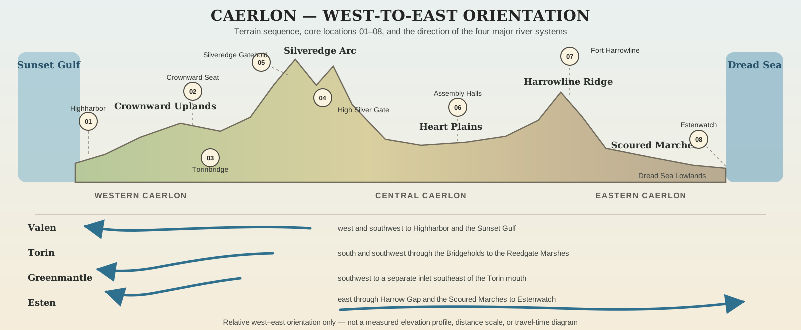


Western Caerlon
Western Caerlon contains the Crownward Uplands, the Valen basin, the Torin basin, the Elderidge Hills, the Verdant Terraces, and the principal approaches to the Sunset Gulf.
The Crownward Uplands lie west of the Silveredge Arc. They are raised, cultivated country crossed by old roads and linked to the middle Valen. The Crownward Seat stands south of the river on an elevated terrace rather than directly on its bank.
The Elderidge Hills form a broken interior highland between portions of the western river systems. They are lower and less continuous than the Silveredge Arc, with valleys, saddles, springs, cultivated slopes, and local crossings rather than an unbroken mountain wall.
Southwestern Caerlon descends through the Verdant Terraces toward the Sunset Gulf. The Greenmantle crosses these cultivated slopes before reaching a sheltered inlet southeast of the Torin mouth.
Central Caerlon
The Silveredge Arc is Caerlon’s principal watershed divide. Its western slopes feed the Valen and contribute to the Torin basin. Its eastern face feeds the Esten.
The range controls movement without completely sealing one half of the continent from the other. High Silver Gate is the principal continent-scale passage between the upper Valen and upper Esten watersheds. Silveredge Gatehold occupies the western and higher approach to the pass.
East of the mountains, the land opens into the Heart Plains, Caerlon’s broad central agricultural basin. The plains lie mainly south of the Esten and north of the Torin basin. Assembly Ridge rises within this wider country and provides dry ground for the Heartplain Assembly Halls.
Eastern Caerlon
Farther east, Harrowline Ridge rises between the Heart Plains and the deepest Scoured Marches. The Esten cuts through the ridge at Harrow Gap. Fort Harrowline stands on the northern height above the crossing.
Beyond Harrowline, the land descends through the Scoured Marches and the Dread Sea Lowlands. The Marches are not one empty wasteland. They contain rebuilt settlements, working fields, ruined estates, river flats, surviving woods, old fortifications, abandoned ground, and areas where travel remains uncertain.
The lower Esten crosses this eastern country before reaching the Dread Sea at Estenwatch. The eastern coast and offshore waters form Caerlon’s approach toward the Broken Chain and Vorrak.
The Four Major Rivers
The Valen
The River Valen rises at Valen Crown Springs on the northwestern slopes of the Silveredge Arc. It flows west through the upper valley, turns southwest through the western interior, and reaches the Sunset Gulf at Highharbor.
Valen Crown Bridge marks an important upper crossing. Farther downstream, the river passes north of the Crownward Seat before widening into its tidal lower reach. Highharbor occupies both sides of the estuary at the river mouth.
The Torin
The River Torin rises in the Elderidge–Silveredge Saddle and flows south and southwest through the Torin Freeholds. Its principal Bridgeholds occur in downstream order: Northchain Hold, Stonewake Hold, Torinbridge, Lowspan Hold, and Reedgate Hold.
Below Reedgate, the Torin enters the Reedgate Marshes and divides before reaching the Sunset Gulf south of Highharbor. The Torin is a separate river system with its own crossings and outlet; it does not join the Valen or Greenmantle.
The Greenmantle
The Greenmantle River rises in the southern Elderidge Hills and flows southwest through the Verdant Terraces. The Verdant Court of Returning Heirs stands on a right-bank terrace above its middle course.
The river reaches a sheltered Sunset Gulf inlet southeast of the Torin mouth. Its separate outlet is essential to the geography of the Verdant Principalities.
The Esten
The River Esten rises at Eastfall Tarn on the eastern face of the Silveredge Arc and flows east across the continent. It passes north of the Heartplain Assembly Halls, cuts through Harrowline Ridge at Harrow Gap, and continues through the Scoured Marches.
Bellweather Run joins the Esten from the south below Harrow Gap. Bellweather Ford Ruins stand on that tributary, while New Bellweather occupies higher ground eighteen miles to the west. The Esten reaches the Dread Sea at Estenwatch, which stands on the downstream right-bank headland—the southern bank of the east-flowing river.
Regions of Caerlon
Caerlon’s eleven regions are geographic, cultural, historical, or political areas rather than perfectly surveyed provinces. Some boundaries follow rivers or ridges. Others are broad transitions recognized by local identity, road use, settlement patterns, or postwar authority.
| Region | Where it lies | Geographic character |
|---|---|---|
| Crownward Remnant | Western-central Caerlon, west of the Silveredge Arc and south of the middle Valen | Crownward Uplands, old administrative centers, archive country, and restored road approaches |
| Heart Plains | Broad central basin east and southeast of Crownward | Grain country, assembly settlements, riverward roads, and open agricultural continuity |
| Scoured Marches | Eastern Caerlon from Harrowline toward the Dread Sea | Rebuilt western ground, contested interior, damaged coastward country, and the lower Esten corridor |
| Highharbor Coast | Western coast around the lower Valen and Sunset Gulf | Estuary, headlands, tidal flats, ship approaches, and Caerlon’s principal western port |
| Torin Freeholds | Along the Torin from the upper valley to Reedgate Marshes | Bridgeholds, ferries, river settlements, and separate local jurisdictions |
| Valenic Compact | Along the upper and middle Valen above Highharbor’s tidal reach | River towns, mills, ferries, grain movement, and linked valley communities |
| Estenmark | Eastern-central Caerlon along the upper and middle Esten | River crossings, supply settlements, military roads, and the approach toward Harrowline |
| Verdant Principalities | Southwestern Caerlon | Terraces, orchards, estates, canals, court settlements, and the Greenmantle valley |
| Silveredge Holds | Along the Silveredge Arc | Mountain settlements, mines, passes, signal sites, and fortified ledges |
| Elderidge Oathlands | Western interior around the Elderidge Hills | Hill roads, springs, old crossings, witness places, and gradual boundary country |
| Broken Chain Approaches | Eastern coast and offshore waters facing the Broken Chain | Coastal stations, patrol waters, quarantine islets, channels, wreck sites, and invasion-route memory |
The Dread Sea Coast is a physical coastline rather than a twelfth canonical region. Its settlements and waters are treated primarily through the Scoured Marches and Broken Chain Approaches.
Major Places on the Numbered Atlas
Core Sites
| No. | Place | Why it matters |
|---|---|---|
| 01 | Highharbor | Principal western deepwater gateway at the Valen estuary |
| 02 | Crownward Seat | Old administrative center on the Crownward Uplands |
| 03 | Torinbridge | Principal fixed crossing and major settlement of the middle Torin |
| 04 | High Silver Gate | Main continent-scale passage across the Silveredge watershed |
| 05 | Silveredge Gatehold | Fortified settlement above the western approach to High Silver Gate |
| 06 | Heartplain Assembly Halls | Central civic and assembly site on dry ground between the Esten and Torin basins |
| 07 | Fort Harrowline | Fortress overlooking the Esten crossing through Harrow Gap |
| 08 | Estenwatch | Eastern fortress-port at the Esten mouth on the Dread Sea |
Secondary Sites
| No. | Place | Why it matters |
|---|---|---|
| 09 | Valen Crown Bridge | Upper Valen bridge and gateway below the river’s springs |
| 10 | Northchain Hold | Northernmost principal Torin Bridgehold |
| 11 | Stonewake Hold | Torin crossing between Northchain and Torinbridge |
| 12 | Lowspan Hold | Torin Bridgehold downstream of Torinbridge |
| 13 | Reedgate Hold | Lowest fixed Torin crossing before the Reedgate Marshes |
| 14 | Verdant Court | Map shorthand for the Verdant Court of Returning Heirs above the Greenmantle |
| 15 | New Bellweather | Rebuilt settlement on higher ground west of Bellweather Ford Ruins |
| 16 | Bellweather Ford | Map shorthand for Bellweather Ford Ruins on Bellweather Run |
Approaching Caerlon
From the Sunset Gulf
The principal confirmed western maritime approach reaches Highharbor through the Sunset Gulf. A vessel approaching the city first encounters the Valen estuary, its headlands, outer traffic, and the distinction between the two riverbanks.
The Torin and Greenmantle also reach the Sunset Gulf through separate southern outlets. Their mouths provide regional access but do not share Highharbor’s estuary.
From the Dread Sea
The principal confirmed eastern river approach reaches Estenwatch. Its headland position marks the recognized entrance to the lower Esten and the strongest direct connection between the Dread Sea and Caerlon’s interior river corridor.
Other eastern landings and offshore sites exist, but the continental atlas does not attempt to show every cove, islet, ruined quay, patrol station, or quarantine point.
Through the Broken Chain
The Broken Chain is an island and open-water crossing system, not a continuous land bridge. At continental scale, the map establishes the direction of the approach rather than every island, channel, station, or hazard within it.
The route remains central to Caerlonian memory because the invasion from Vorrak crossed the Dread Sea through the Broken Chain and entered eastern Caerlon.
Traveling Across the Continent
Caerlon’s broad movement pattern follows its terrain.
The Valen supports the principal western river corridor. The Torin is organized around a sequence of Bridgeholds rather than one single crossing authority. High Silver Gate provides the clearest passage between the western and eastern watersheds. The Heart Plains form the central open country through which several overland connections must pass. The Esten provides the strongest continuous route toward eastern Caerlon. Harrow Gap is the principal controlled break through Harrowline Ridge.
The physical atlas does not define exact roads, travel times, ferry schedules, seasonal closures, or legal restrictions. Those depend on the route used, mode of travel, weather, road or river condition, inspection requirements, and the current state of the Scoured Marches.
At this scale, the map answers the questions that must remain stable: which side of the Silveredge Arc a place lies on, which river system supports it, which gateway or crossing controls ordinary access, and what lies upstream, downstream, inland, or seaward from it.
The Continental Pattern
Caerlon is arranged around a mountain divide and two opposing maritime faces.
West of the Silveredge Arc lie the Valen, Torin, Greenmantle, Crownward Uplands, Elderidge Hills, Verdant Terraces, Highharbor, and the Sunset Gulf approaches.
East of the divide lie the upper Esten, Heart Plains, Harrowline Ridge, Scoured Marches, Estenwatch, Dread Sea coast, and Broken Chain Approaches.
High Silver Gate links the two sides. Harrowline marks the strongest threshold into the eastern Marches. Highharbor opens Caerlon toward the western seas. Estenwatch opens the lower Esten toward the Dread Sea.
The geography does not decide who should rule Caerlon. It establishes the watersheds, crossings, gateways, and bottlenecks through which every later question of food, travel, defense, trade, law, reconstruction, and authority must operate.