Appearance
Caerlon — Terrain, Elevation, and Landforms
Caerlon rises and falls in two great stages. From the Sunset Gulf, the western land climbs through coastal ground, river country, cultivated terraces, and uplands toward the Silveredge Arc, the continent’s principal mountain divide. East of the range, the land opens into the Heart Plains, rises again at Harrowline Ridge, and then descends through the Scoured Marches and Dread Sea Lowlands to the eastern coast.
These landforms help explain why Caerlon has several centers of population and authority rather than one natural capital. Rivers drain in opposite directions. Mountain crossings concentrate movement. Broad plains support cultivation and large settlements. Ridges and damaged eastern ground narrow the places through which travelers, armies, and supplies can pass.
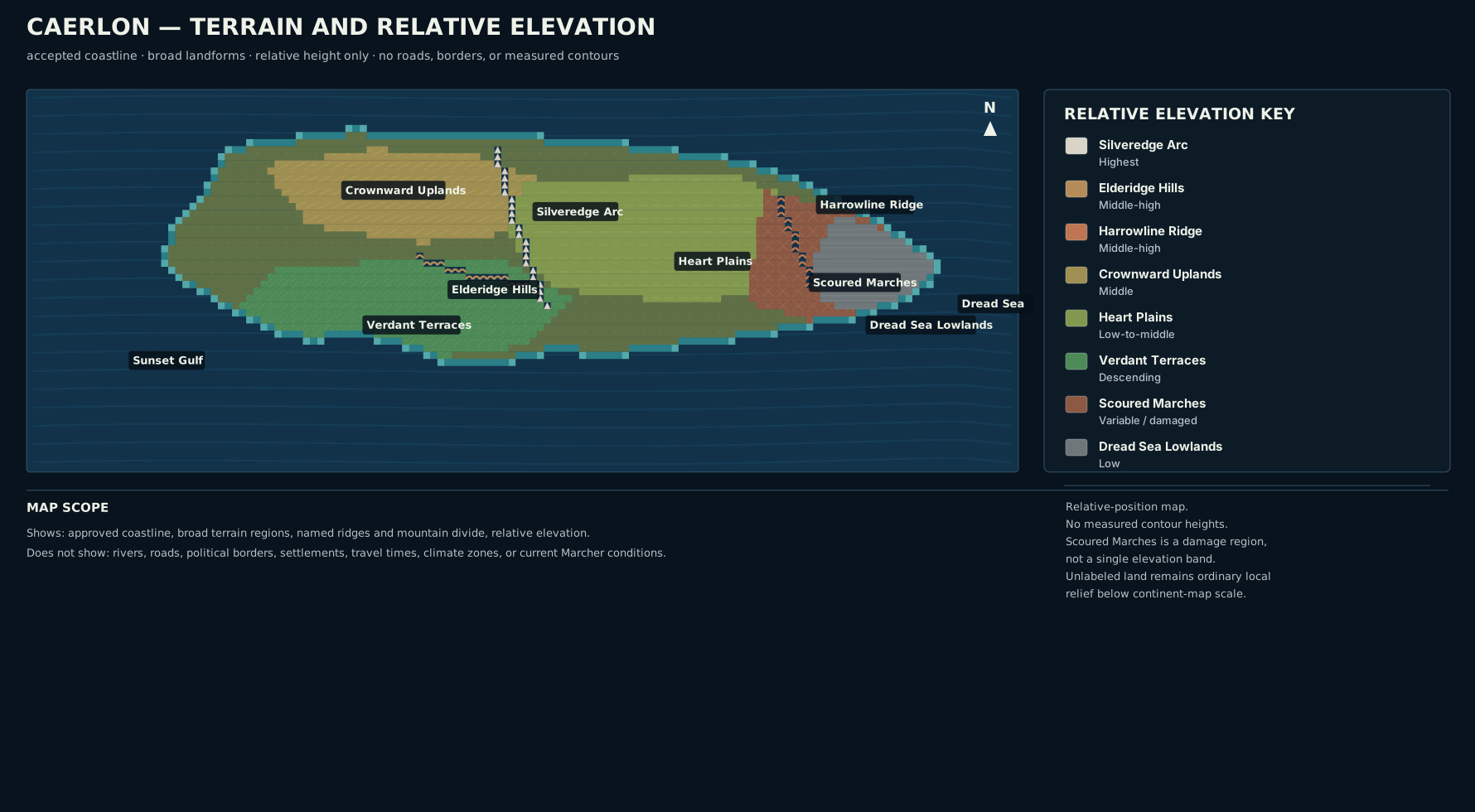
Terrain and relative elevation of Caerlon. The map uses the coastline and broad terrain structure shown in Caerlon’s physical atlas. Elevation is relative rather than measured, and the map is not a distance or travel-time chart.
Open the full terrain map · Read the terrain-map description

Reading Relative Elevation
Caerlon’s continental atlas establishes relative height rather than exact elevation above sea level. These categories show which features rise above their surroundings without assigning unsupported measurements.
| Relative class | Principal features | What the class means |
|---|---|---|
| Highest continental ground | Silveredge Arc | The main mountain divide, containing the continent’s highest named terrain and its principal cross-watershed passage |
| Middle-high ground | Elderidge Hills; Harrowline Ridge | Prominent hills and ridges that shape drainage, sightlines, and movement without matching the height or continuity of the Silveredge Arc |
| Middle ground | Crownward Uplands; upper Verdant Terraces | Raised country above adjoining river flats and coastal lowlands |
| Low-to-middle ground | Heart Plains; lower Verdant Terraces; western river country | Broad settled terrain with gradual slopes, shallow valleys, and local rises |
| Low ground | Dread Sea Lowlands; estuary and coastal margins | Ground descending toward tidal water, river mouths, flood-prone flats, and exposed coast |
| Variable ground | Scoured Marches | A historical damage region crossing more than one elevation class rather than a single natural landform |
A terrain name describes the dominant form of a broad area, not every field or hillside within it. Plains contain stream valleys and low ridges. Uplands include sheltered basins. Lowlands can contain defensible headlands. The continent’s named features provide orientation while leaving room for ordinary local terrain between them.
The Continental Rise
The profile below shows Caerlon’s broad west-to-east shape. It is vertically exaggerated so the principal landforms remain legible.
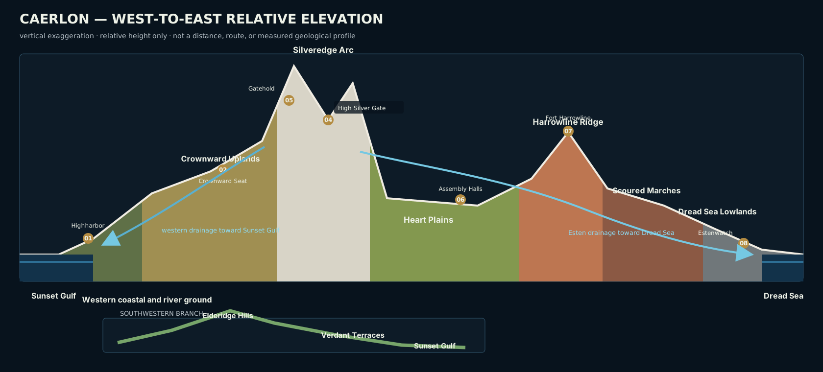
Relative elevation profile showing selected major sites, not a measured cross-section. The southwestern Verdant–Elderidge descent appears as a secondary branch beneath the main continental profile.
Open the full elevation profile · Read the profile description

The strongest rise is the Silveredge Arc. It creates a true western and eastern side to the continent, separates the Valen system from the Esten watershed, and makes the position of a pass a continental concern. Harrowline Ridge is lower and narrower, but it creates a second threshold farther east. Between them lies the Heart Plains basin. Beyond Harrowline, the land slopes toward the Dread Sea.
The southwest follows a different profile. The Elderidge Hills divide the interior into smaller valleys and saddles before the Verdant Terraces descend toward the Sunset Gulf. This country is elevated and varied, but it does not form a second mountain wall.
Western Caerlon
The Crownward Uplands
The Crownward Uplands occupy western-central Caerlon, west of the Silveredge Arc. They are raised limestone and cultivated country rather than mountains: broad terraces, low ridges, quarry ground, springs, shallow valleys, and long-settled sites above the lower Valen basin.
The uplands give the Crownward heartlands defensible, well-drained ground without isolating them from the river. The Crownward Seat stands on a raised terrace south of the middle Valen. Its position protects it from ordinary river flooding while keeping it close enough to depend on river landings and the descending roads that connect them.
From much of the upland, the Silveredge Arc dominates the eastern horizon. Westward, the country falls toward the Valen, Highharbor, and the Sunset Gulf. The transition is gradual. There is no single cliff or surveyed line where the uplands end and the river country begins.
The Elderidge Hills
The Elderidge Hills lie in the western interior between portions of the Valen, Torin, and Greenmantle drainage systems. They are broken hill country, not a continuous range. Valleys, saddles, springs, cultivated slopes, and local crossings pass among the ridges.
Their importance comes from division without complete separation. Water falling on different sides of neighboring hills may enter different western rivers. Communities only a short distance apart can therefore face different market towns, bridge systems, flood risks, and travel corridors.
The hills also interrupt long sightlines. A settlement can be close in direct distance while remaining hidden behind two ridges and reachable only through a particular saddle. Local knowledge matters here because the useful route is not always the route that looks shortest on a broad map.
The Verdant Terraces
The Verdant Terraces descend southwest from the southern Elderidge country toward the Sunset Gulf. “Terraces” describes the stepped character of the land: cultivated slopes, river benches, orchard ridges, estate valleys, and lower coastal shelves. It does not mean the entire region has been engineered into regular agricultural steps.
The Greenmantle crosses these descending lands before reaching its own sheltered gulf inlet. Higher ground provides dry sites above the river, while lower terraces open toward coastal cultivation and local landings. The Verdant Court of Returning Heirs stands above the river’s middle course rather than on the lowest flood ground.
The transition from Elderidge hills to Verdant terraces is gradual. Hill farms, orchards, woods, old estates, and river valleys overlap across the descent.
The Silveredge Arc
The Silveredge Arc is the principal mountain system of Caerlon. It runs north–south through western-central Caerlon and forms the continent’s principal watershed divide. The Valen rises on its northwestern slopes. The Esten begins on its eastern face. The Torin rises farther south in the Elderidge–Silveredge Saddle.
The range is long enough to channel movement but not perfectly continuous. Lesser tracks, mining approaches, local saddles, and hold paths exist along it. At continental scale, however, High Silver Gate is the principal passage connecting the upper Valen side with the upper Esten valley.
High ground brings steep slopes, exposed ledges, narrow valleys, rockfall channels, snow-retaining faces, and long sightlines. A pass may be closed while lower country remains open, and a settlement on a sheltered ledge may experience very different conditions from another settlement only a few miles away on an exposed face.
High Silver Gate and Silveredge Gatehold
High Silver Gate and Silveredge Gatehold are separate features. The Gate is the pass through the mountain divide. The Gatehold is the fortified settlement standing on the western and higher ledge above the pass.
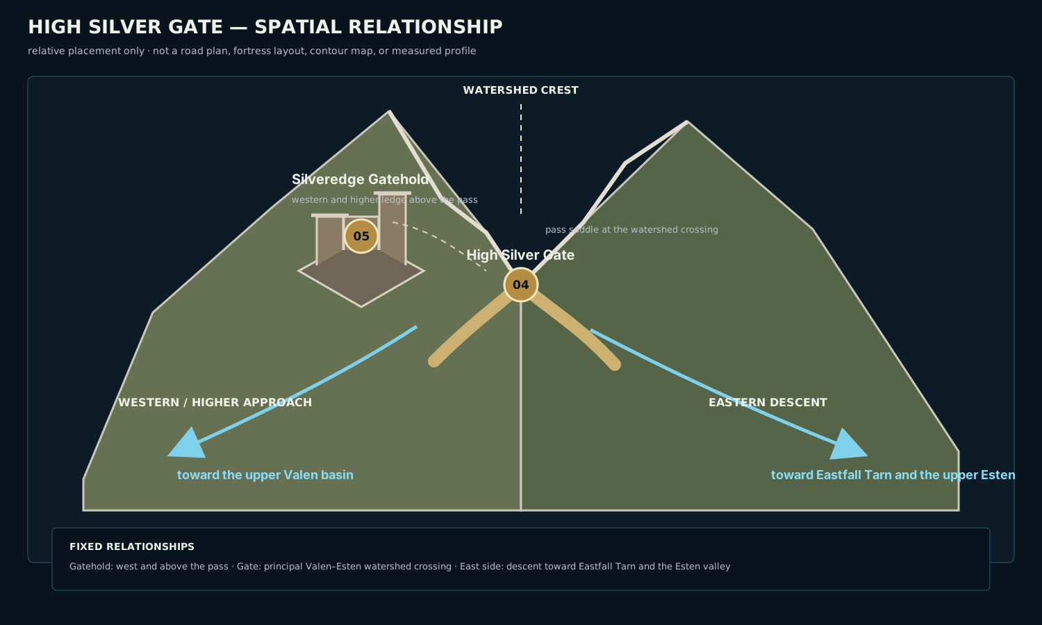
Spatial relationship diagram showing the relative positions of the pass, gatehold, watershed, and eastern and western approaches. It is not a road plan, settlement map, or measured elevation drawing.
Open the High Silver Gate diagram · Read the diagram description

A traveler coming from the west climbs from the upper Valen side toward the Gatehold’s ledge before reaching the watershed crossing. Beyond the pass, the ground falls toward Eastfall Tarn and the upper Esten. The Gatehold’s higher western position allows it to observe the approach without occupying the saddle itself.
The terrain fixes the relationship among ledge, pass, watershed, and descent. Roads, mines, walls, and local approaches follow that structure but are separate features within it.
Central Caerlon
The Heart Plains
The Heart Plains form the broad central basin east and southeast of the Crownward Uplands. They lie mainly east of the Silveredge Arc, south of the Esten, and north of the Torin basin.
The plains are broad rather than perfectly flat. Their surface includes shallow tributary valleys, gravel rises, mill streams, flood-prone fields, low ridges, and old disturbed ground. These differences matter locally, but none breaks the overall continuity of the basin.
Their scale allows extensive cultivation, numerous settlements, storage centers, assembly sites, and several major lines of movement across central Caerlon. A traveler crossing the Heart Plains can pass through many different local jurisdictions without leaving the same broad geographic basin.
Assembly Ridge
The Heartplain Assembly Halls stand on Assembly Ridge, a dry rise within the wider plain. The ridge is not a mountain or a separate regional barrier. It is local high ground positioned south of the Esten and north of the Torin basin.
That placement keeps the assembly site above ordinary flood ground and near the center of the plain without putting it directly on either major river. From the ridge, travelers can orient themselves by the Silveredge Arc to the west and Harrowline Ridge to the east.
Eastern Caerlon
Harrowline Ridge and Harrow Gap
Harrowline Ridge stands east of the Heart Plains and west of the deepest Scoured Marches. It is lower and shorter than the Silveredge Arc, but it creates Caerlon’s clearest eastern interior threshold.
The Esten crosses the ridge through Harrow Gap. Fort Harrowline stands on the northern height above that crossing. The ridge therefore shapes movement without forming an absolute wall: routes that avoid the gap must contend with less direct, less developed, or more difficult ground.
Harrowline remains well inland from the Dread Sea. Considerable Marcher and lowland country lies between the ridge and the coast.
The Scoured Marches
The Scoured Marches are a broad eastern damage region, not a natural elevation band. Their western reaches include ground descending from Harrowline. Their deeper and coastward reaches extend across lower terrain toward the Dread Sea.
The invasion damaged settlements, fields, woods, drainage works, roads, and fortifications, but it did not transform every part of the Marches into the same barren surface. Rebuilt farmland, surviving woods, river flats, ruined estates, abandoned ground, burial fields, damaged wetlands, and low coastal country all occur within the region.
The Marches are best understood as history laid over geography. Beneath the damage remain ordinary slopes, valleys, floodplains, ridges, woods, and settled ground. The degree of destruction, repair, abandonment, and safe access changes from place to place without changing the underlying landform.
The Dread Sea Lowlands
The Dread Sea Lowlands form the eastern descent from the interior Marches to the coast. They include lower river country, tidal and estuarine ground, exposed coastal flats, low ridges, and the approaches to the Esten mouth.
The lowlands are not uniformly marshy or undefended. Estenwatch occupies a strong right-bank headland above the lowest surrounding ground. Other settlements and defensive sites may stand on local rises, old earthworks, or firmer coastal shelves.
Low elevation makes drainage, flooding, tides, and coastal exposure important throughout this eastern descent. Even small changes in height can determine whether a road remains passable, a settlement floods, or a watch position commands the surrounding flats.
Reading the Land While Traveling
Caerlon’s largest landforms remain useful even when no map is at hand.
In western Caerlon, the Silveredge Arc is the clearest long-distance landmark. Its higher peaks rise above the Crownward Uplands and upper Valen country, while the lower Elderidge ridges interrupt sightlines farther south. A traveler in the Elderidge Hills may know the correct direction yet still need a local saddle or valley to make progress.
The Heart Plains feel different from the western uplands. The horizon opens, the slopes become shallower, and settlements are more often visible at a distance. Assembly Ridge and other local rises stand out because the surrounding basin is broad rather than steep.
Approaching Harrowline from the west, the ridge appears as a distinct second rise beyond the plains. Harrow Gap is the principal break in that line. East of the ridge, the landscape does not suddenly become a wasteland. Instead, ordinary terrain is marked by damaged works, interrupted settlement, repaired fields, ruined walls, and stretches whose present condition may differ sharply from the ground around them.
Near the Dread Sea, lower ground, tidal influence, broad river mouths, and exposed headlands become the strongest orientation features. Estenwatch is visible because it occupies one of those stronger heights above the surrounding lowlands.
The Ground Between Named Features
Continental maps name only landforms large enough to organize the continent. Broad areas remain without a formal texture or label. Those spaces are not empty. They contain rolling ground, local valleys, woods, fields, minor ridges, stream basins, and settlement country whose importance is regional rather than continental.
A local landscape inherits the shape of the larger terrain around it. A valley west of Silveredge drains toward a western river system. A settlement in the Heart Plains occupies broad basin country even when it stands on a low rise. A Marcher ruin may sit in woods, floodplain, or coastal lowland while still belonging to the same historically damaged region.
This relationship between broad landform and local detail keeps Caerlon legible without requiring every hill, stream, and field to carry a continent-scale name.
Terrain in Play
At the table, continent-scale terrain establishes expectations rather than automatic encounter-scale mechanics. A Silveredge route may include steep slopes, scree, narrow ledges, or severe weather. Elderidge travel may involve repeated climbs, concealed valleys, and limited sightlines. The Heart Plains favor broad visibility and easier overland movement, but mud, floodwater, disturbed fields, and shallow channels can still obstruct travel. Marcher ground may combine ordinary terrain with rubble, damaged works, unstable surfaces, or publicly marked hazard areas.
Local maps and encounters determine whether a space counts as difficult terrain, greater difficult terrain, uneven ground, or an environmental hazard under Pathfinder Second Edition Remaster rules. No entire continent-scale region carries one universal movement penalty.
Terrain also shapes exploration choices. Characters may seek higher ground for orientation, follow valleys to avoid steep climbs, use ridgelines for visibility, or choose a longer but more reliable crossing. Travel time depends on the route, season, mode of travel, and the condition of the ground rather than on straight-line distance alone.
Map Scope
The terrain map and diagrams on this page establish:
- the continental coastline;
- the broad placement of the eight major terrain features;
- relative elevation classes;
- the Silveredge watershed divide;
- the inland position of Harrowline Ridge;
- the broad west-to-east continental profile;
- the relative positions of High Silver Gate and Silveredge Gatehold.
They do not establish exact measured elevations, geological ages, political borders, road geometry, settlement districts, mine layouts, weather calendars, travel times, or current Marcher safety conditions.