Appearance
Caerlon — Routes, Travel Times, and Navigation
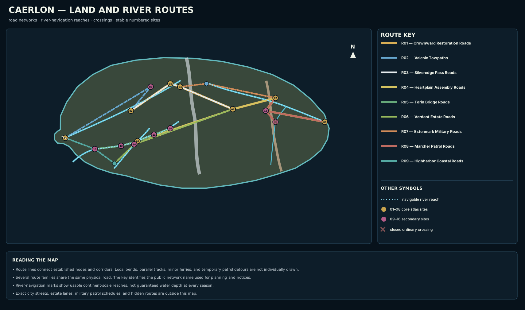
Caerlon’s roads and rivers form one connected movement system. The western ports feed the Valen, Torin, and Greenmantle corridors. High Silver Gate carries the principal east–west crossing through the Silveredge Arc. The Heart Plains connect the mountain road to Torin, Verdant, and Harrowline traffic. East of Harrow Gap, the Marcher roads and lower Esten lead toward Estenwatch and the Dread Sea.
Travel is possible across the continent, but a line on a map is not the same as an open route. Flood, snow, bridge repair, road authority, military notice, quarantine, harvest traffic, and current reports from the Scoured Marches can change an ordinary journey by hours, days, or an indefinite closure.


How to Read the Travel Times
Caerlonians usually plan long journeys in route days rather than straight-line distance. A route day assumes approximately eight hours of determined but non-exhausting travel, ordinary rests, an open public route, and no unusually long inspection or weather delay.
The ordinary overland times use two common planning paces:
| Traveler or conveyance | Ordinary clear-route pace |
|---|---|
| A party whose slowest member has a Speed of 25 feet | About 20 miles per day |
| A loaded cart, mixed convoy, or party limited to an effective Speed of 20 feet | About 16 miles per day |
| Mountain movement through the High Silver approaches | Usually 10–12 miles per day |
Difficult terrain commonly halves progress. Greater difficult terrain can reduce it to one-third. A party that spends much of the day Scouting, Searching, Investigating, Defending, or Avoiding Notice also moves more slowly. River and sea times use the route’s own current, wind, landing, and waiting assumptions rather than character Speed.
The times below are rounded planning figures. A half-day leg may still require an overnight stay when a gate, ferry, or safe lodging place closes before the travelers arrive.
The Main East–West Journey
The most legible cross-continent itinerary begins at Highharbor, follows the Valen corridor to Crownward country, crosses Silveredge through High Silver Gate, reaches the Heart Plains, passes Harrowline, and continues through the Scoured Marches to Estenwatch.
| Leg | Ordinary foot party | Loaded cart or convoy | Common reason for delay |
|---|---|---|---|
| Highharbor to Valen Crown Bridge | 7 days | 9 days | Flood, bank damage, bridge inspection |
| Valen Crown Bridge to Crownward Seat | 2–3 days | 3 days | Terrace-road traffic or road works |
| Crownward Seat to Silveredge Gatehold | 4 days | 5 days | Grade, mine traffic, weather report |
| Gatehold to High Silver Gate | 4–6 hours | 1 day | Inspection, ice, wind, wagon spacing |
| High Silver Gate to Heartplain Assembly Halls | 5 days | 6 days | Eastern descent, mud, plain-road congestion |
| Assembly Halls to Fort Harrowline | 3 days | 4 days | Floodplain detour or military inspection |
| Fort Harrowline to New Bellweather | 1–2 days | 2 days | Marcher notice or escort requirement |
| New Bellweather to Estenwatch | 5 days | 6 days | Patrol closure, damaged crossing, threat report |
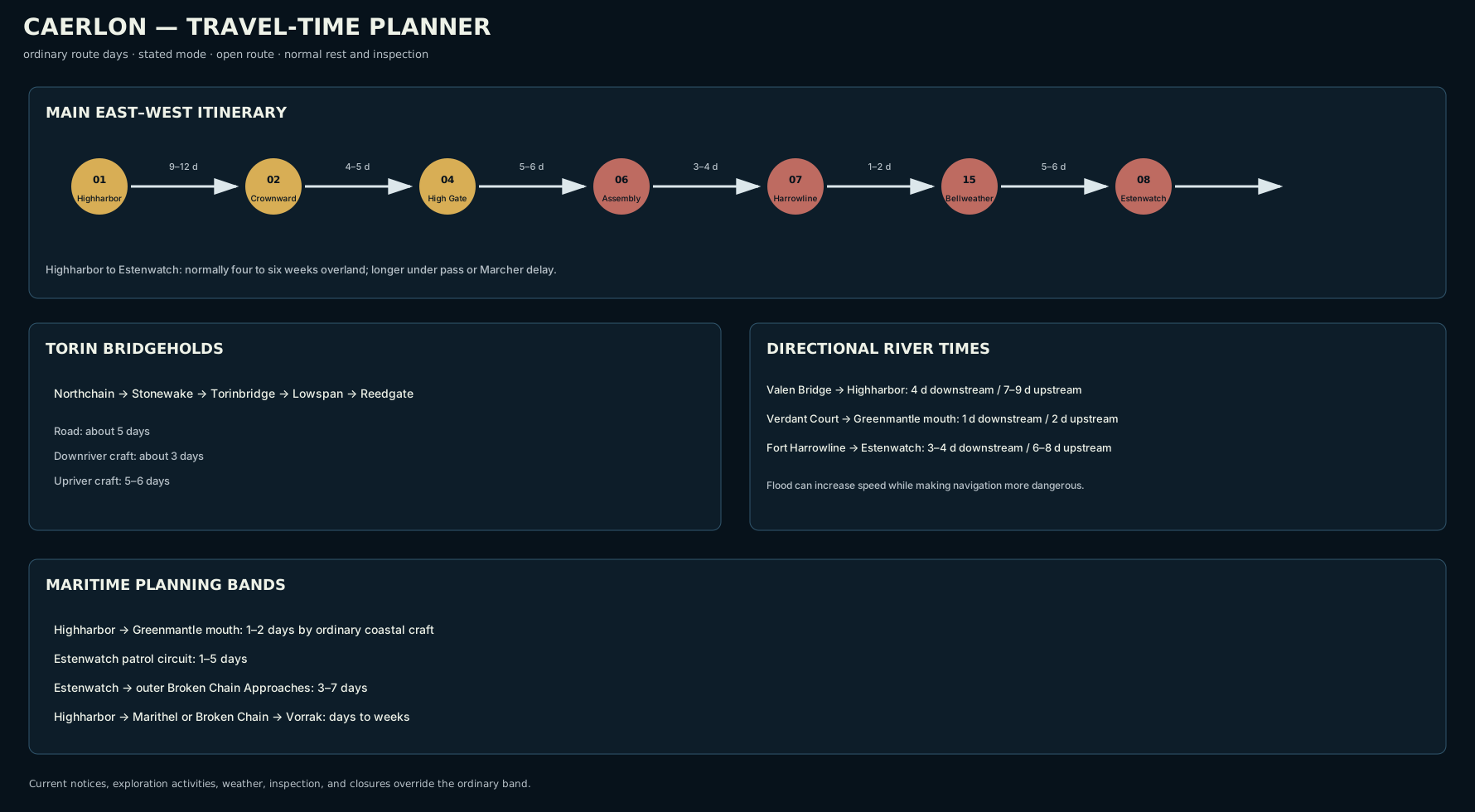
A traveler going from Highharbor to Crownward Seat normally plans nine to twelve days. Crownward Seat to the Heartplain Assembly Halls takes another nine to twelve days through an open High Silver Gate. Heartplain Assembly Halls to Estenwatch generally requires nine to fourteen days.
The complete western-port-to-eastern-port journey therefore takes about four to six weeks under ordinary conditions. A courier using relays and traveling without a heavy load can do better. A refugee convoy, grain train, cautious adventuring party, or route under repeated inspection can take longer.
Crownward and the Valen Corridor
The Valenic Towpaths join Highharbor to the upper Valen and Valen Crown Bridge. Towpaths, riverside roads, barge landings, ferries, and bridge approaches form one corridor rather than a single paved road.
Downriver cargo normally moves faster than road traffic. A barge from Valen Crown Bridge to Highharbor plans for about four days in ordinary water. Upriver travel commonly takes seven to nine days because towing, poling, current, and landing delays work against the vessel. The parallel towpath takes about seven days on foot or nine days with a loaded cart.
Crownward Seat lies south of the middle Valen on raised ground. The road from Valen Crown Bridge to the city takes two to three days and climbs away from the floodplain. Road Glass Station at Mile 0 in Crownward Seat is the ceremonial and practical reference point for the restored Crownward road network.
The Crownward Restoration Roads continue east from the city. They are not owned or maintained by one authority for their full length. Crownward offices, Silveredge wardens, Heartplain councils, Estenmark road authorities, and Marcher patrols each control different parts of the journey.
High Silver Gate and the Central Roads
The Silveredge Pass Roads connect Crownward Seat to Silveredge Gatehold, High Silver Gate, the eastern descent, and the Heart Plains. Gatehold stands on the higher western ledge above the lower pass saddle. Travelers normally stop there for weather, shelter, cart spacing, or closure information before entering the exposed crossing.
The pass itself is a short leg measured in hours rather than days, but it can determine the entire journey. Snow, ice, high wind, falling stone, poor visibility, or lack of shelter space can close it even when the roads on both sides remain usable.
East of the range, the Heartplain Assembly Roads spread from the Assembly Halls toward Torinbridge, the Verdant Principalities, Estenmark, and Fort Harrowline. These are working grain and market roads. Their travel time is often governed as much by convoy congestion, bridge status, and spring mud as by distance.
Major central legs include:
| Route leg | Ordinary time |
|---|---|
| Heartplain Assembly Halls to Fort Harrowline | 3–4 days |
| Heartplain Assembly Halls to Torinbridge | 7–9 days |
| Heartplain Assembly Halls to Verdant Court | 7–9 days |
| High Silver Gate to Fort Harrowline by the Estenmark roads | 7–9 days |
The Torin Bridge Road
The Torin Bridgeholds form the clearest ordered regional itinerary in western Caerlon:
text
Northchain Hold
→ Stonewake Hold
→ Torinbridge
→ Lowspan Hold
→ Reedgate Hold
Travelers going downstream by road normally spend about one day between each of the first four settlements and two days between Lowspan and Reedgate. The complete road journey is usually five days before unusual toll, repair, or ferry delays.
Small craft can descend from Northchain to Reedgate in about three days under ordinary conditions. The upriver journey takes five to six days. Bridge clearance, low water, flood debris, toll hearings, and the need to unload around a damaged span can extend either trip.
Torinbridge is the main transfer point between the river road and the Heartplain Assembly Roads. The overland journey from Torinbridge to the Assembly Halls takes about seven to nine days.
The Greenmantle and Verdant Roads
The Verdant Estate Roads climb from the Greenmantle river mouth through terrace and estate country to Verdant Court, then continue northeast toward the Heart Plains.
The river mouth to Verdant Court is a two- to three-day road journey. Small craft normally descend the middle Greenmantle in one day and return upriver in two. The longer road from Verdant Court to the Heartplain Assembly Halls requires about seven to nine days.
The Greenmantle route does not end at one public port. Ordinary arrivals use a mixture of communal riverbank landings, private estate landings, and smaller coastal craft. Travelers carrying large cargo often arrange a transfer before entering the river.
Estenmark and the Scoured Marches
The Estenmark Military Roads follow the upper and middle Esten from the eastern Silveredge approaches toward Harrowline. These roads carry ordinary travelers, supply wagons, patrol traffic, and reconstruction work, but military inspection can take priority.
High Silver Gate to Fort Harrowline normally takes seven to nine days. Some usable Esten reaches support boats or barges, but the upper river is not uniformly navigable and travel through Harrow Gap depends on current conditions.
East of the gap, the Marcher Patrol Roads connect Fort Harrowline, New Bellweather, the Bellweather country, and Estenwatch. An open-road notice means that patrols and settlements currently recognize the route as usable. It does not guarantee that every side road, ruin, field, or former crossing is safe.
Fort Harrowline to Estenwatch takes seven to ten days by road under an open notice. Downriver craft can cover the usable lower Esten in three to four days. Upriver craft usually require six to eight days.
Bellweather Ford Ruins are not an ordinary open crossing. The spur from New Bellweather takes about one day, but continued use of the ruined ford requires a current local report or an alternate crossing.
Western Coastal Movement
Highharbor Coastal Roads remain on the Sunset Gulf side of Caerlon. They connect Highharbor southward to Reedgate and the Greenmantle mouth. They do not continue across the continent to the Dread Sea.
Highharbor to Reedgate is normally two to three days by road or about one day by coastal craft. Reedgate to the Greenmantle mouth takes another two days by road or less than a day by favorable coastal passage. Marsh flooding and gulf storms can force road and water traffic to wait at different times.
Highharbor’s two banks are linked by ordinary cross-estuary ferries rather than a continent-scale bridge. A routine crossing takes roughly twenty to forty minutes, with ordinary waits ranging from fifteen minutes to two hours. Exact landing locations belong to the city map.
River Navigation
The four principal rivers support different craft and different directional times.
| River reach | Downstream planning time | Upstream planning time | Ordinary navigation limit or complication |
|---|---|---|---|
| Valen Crown Bridge to Highharbor | About 4 days | 7–9 days | Bridge inspection, towpath condition, flood |
| Northchain Hold to Reedgate Hold | About 3 days | 5–6 days | Northchain is the upper navigation limit at this scale |
| Verdant Court to the Greenmantle mouth | About 1 day | About 2 days | Smaller craft and distributed lower landings |
| Fort Harrowline to Estenwatch | 3–4 days | 6–8 days | Harrow Gap, patrol notices, debris, lower-river landings |
River times include ordinary stopping, bridge clearance, and landing delays. A flood can make downstream movement faster and far more dangerous at the same time. Low water can expose bars, prevent loaded craft from passing, or force portage.
Maritime Routes
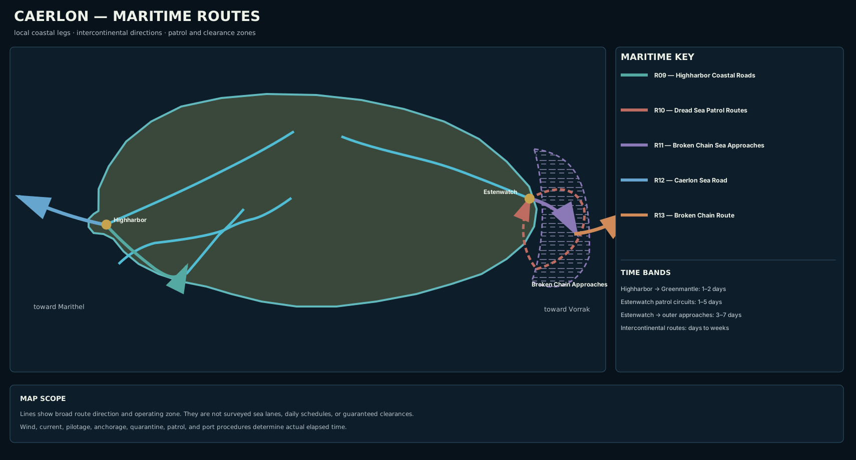


The Caerlon Sea Road leaves Highharbor through the Sunset Gulf toward Marithel. Its ordinary planning time remains days to weeks because vessel type, route window, convoy arrangements, weather, and the exact Maritheli destination matter more than one continent-scale number.
On the Dread Sea side, ordinary patrol circuits from Estenwatch into the Caerlon-facing Broken Chain Approaches last from one to five days. A cleared voyage from Estenwatch through the wider approach zone normally takes three to seven days before the vessel commits to the full intercontinental Broken Chain Route.
The complete Broken Chain crossing toward Vorrak remains a days-to-weeks route with no stable numerical time at this scale. Quarantine, patrol interception, reefs, obsolete charts, anchorage waits, and route closures can dominate the elapsed time.
The Road of the Last Convoy is not shown as an ordinary route. Public accounts describe it as a nonordinary memory passage whose elapsed time does not correspond reliably to geographic distance.
Travel-Time Planner


Finding the Route
Caerlon’s major routes are recognized through repeated practical markers rather than one universal sign system.
Crownward roads use mile and survey references associated with Road Glass Station. Silveredge Gatehold posts pass conditions and shelter limits. Heartplain road kitchens and assembly relays carry bridge, convoy, and grain-road notices. The Bridgeholds post their own crossing and toll information. Fort Harrowline and Marcher settlements issue open-road, escort, and closure notices. Estenwatch and the Broken Chain stations use patrol, pilot, quarantine, and waiting signals.
A traveler should confirm five things before leaving a major stop:
- the next reliable shelter or landing;
- the current bridge, ferry, pass, or channel status;
- the authority issuing the route notice;
- the date or watch period of that notice;
- the alternate stop if the next connection closes.
Old milestones and intact road surfaces are useful, but neither proves that a route remains open. In the Scoured Marches, a newly posted warning can be more reliable than a beautifully restored map.
Pathfinder Second Edition Remaster
Use the party’s slowest relevant Speed when a route is played out through exploration mode. A Speed of 25 feet corresponds to 20 miles per day on flat, clear terrain; a Speed of 20 feet corresponds to 16 miles per day. Difficult terrain halves travel and greater difficult terrain reduces it to one-third.
Exploration activities can also reduce progress. A party that Avoids Notice, Defends, Investigates, Scouts, or Searches for much of the day generally travels at half speed. The route times on this page assume steady travel rather than one of those slower activities.
For river and sea passages, use the listed route time as the normal planning band. Apply local current, wind, fog, storm, vessel damage, waiting, inspection, or closure when the scene requires it. The route map determines where the journey occurs; a local encounter map determines the actual checks, DCs, terrain, and consequences.
Map Scope
The route maps and travel-time records establish:
- the primary Crownward-to-Estenwatch road corridor;
- the Valenic towpath and barge route;
- High Silver Gate as the central overland crossing;
- the Heartplain road branches;
- the ordered Torin Bridgehold route;
- the Greenmantle and Verdant connection;
- the Estenmark and Marcher road systems;
- western coastal movement between Highharbor, Reedgate, and the Greenmantle mouth;
- directional river travel times;
- ordinary ferry and crossing functions;
- Dread Sea patrol and Broken Chain planning bands;
- PF2e-compatible overland travel assumptions.
They do not establish every local road, exact city landing, legal toll, road-maintenance budget, daily sailing schedule, hidden route, military patrol plan, or encounter-specific DC.
← Approaches, Gateways, and Coasts · Settlement Placement and Major Sites →