Appearance
Caerlon — Settlement Placement and Major Sites
Caerlon’s major settlements are not distributed evenly. They gather where water, roads, defensible ground, food, records, trade, or public authority make permanent occupation practical. The western estuaries support ports and river towns. The Silveredge divide concentrates movement at a small number of passes. The Heart Plains support broad networks of farming and market communities. The eastern settlement pattern follows forts, repaired roads, the Esten corridor, and places where resettlement can still be defended.
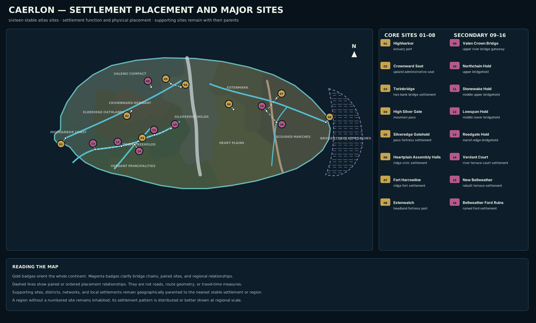
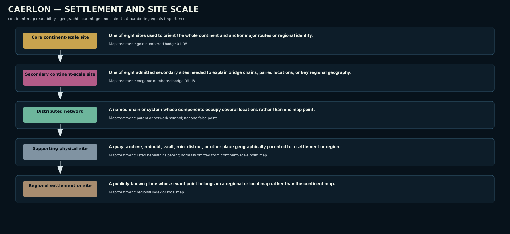
The continent map uses sixteen numbered sites. Eight are core anchors used to orient Caerlon as a whole. Eight are secondary sites needed to explain major bridges, paired settlements, and important local relationships. A numbered point does not mean that the surrounding region contains only one settlement. It means that the place is important enough to remain legible on a continent-scale map.


How Settlement Placement Works
Caerlon’s settlements usually depend on several forms of geography at once.
Water access supports ports, ferries, mills, irrigation, river transport, and food supply. Highharbor, Torinbridge, the Bridgeholds, Verdant Court, and Estenwatch all occupy water-connected sites, but they use that water differently.
Flood-safe ground matters near every major river. Crownward Seat stands above the middle Valen rather than on its bank. Verdant Court occupies a Greenmantle terrace. New Bellweather was rebuilt on raised ground rather than directly on the destroyed ford.
Crossings and bottlenecks concentrate authority. High Silver Gate, Valen Crown Bridge, Torinbridge, the Bridgeholds, Harrow Gap, and Estenwatch all control movement through terrain that offers fewer alternatives.
Food and storage shape the Heart Plains. The Assembly Halls sit among grain roads and storage communities without occupying either the Esten or Torin floodplain.
Observation and defense determine Fort Harrowline, Silveredge Gatehold, and Estenwatch. Each occupies raised ground overlooking an approach that matters beyond the settlement itself.
Historical continuity can keep a place important after ordinary settlement ends. Bellweather Ford Ruins remain a mapped site because roads, families, memorial practice, salvage, and public memory still orient themselves around the destroyed crossing.
Site Scale


Core Sites
Core sites anchor continent-wide orientation. A traveler can use them to understand major coasts, central roads, mountain passage, the Marcher frontier, and the two principal maritime gateways.
Secondary Sites
Secondary sites clarify relationships that a map would otherwise hide. Valen Crown Bridge fixes the upper river transition. Four named Bridgeholds establish the Torin’s downstream order. Verdant Court fixes the Greenmantle court country. New Bellweather and Bellweather Ford Ruins establish the relationship between rebuilding and the destroyed settlement.
Distributed Networks
Some named places are systems rather than points. The Silveredge Signal Holds occupy multiple ledges and valleys. Highharbor Watch Stations extend along the coast. Crownward Road Stations occupy a road network. Broken Chain quarantine and signal sites occupy several islands and approach waters.
A network should not be reduced to one misleading dot.
Supporting Physical Sites
A supporting site may be important without needing a separate continent-scale marker. Saltwatch Quays belongs within Highharbor. The Heartplain Granary Vault belongs to the Assembly Halls settlement. Harrowline Outer Redoubt is positioned in relation to Fort Harrowline. New Bellweather Cellars belong beneath the rebuilt town.
The Eight Core Sites
01 — Highharbor
Highharbor occupies both banks of the Valen estuary where the river reaches the Sunset Gulf. The older city and principal shipyards stand on the downstream right-bank headland, while lower quays, warehouses, and working districts extend across the opposite flats.
The city is placed here because it can receive ocean-going vessels, connect cargo to the lower Valen, overlook the estuary, and maintain large dock, storage, repair, customs, and patrol systems. Saltwatch Quays and Farwake Piers are districts within the city rather than separate coastal towns. Highharbor Watch Stations extend beyond the urban footprint as a distributed coastal network.
02 — Crownward Seat
Crownward Seat stands on raised ground south of the middle Valen. It is near enough to use river landings and the Valenic corridor but high enough to avoid dependence on ordinary floodplain ground.
Its placement supports an administrative city: broad approaches, storage yards, archive districts, ceremonial roads, and connections toward Valen Crown Bridge, Silveredge, and the Heart Plains. The Ashleaf Repository, Crown Crypt of Hollow Oaths, and Road Glass Station at Mile Zero belong to the Crownward Seat urban and road complex.
03 — Torinbridge
Torinbridge occupies both banks of the middle Torin. It is the largest single settlement in the Bridgehold chain and the point where river crossing, road traffic, market activity, toll authority, asylum practice, and freehold politics meet.
The Great Torin crossing and the older damaged span organize the city. The Torin Broken Span and the Tollhouse Underwater Room belong to the crossing district rather than occupying independent continent-scale positions.
04 — High Silver Gate
High Silver Gate is a physical pass rather than a town. It occupies the lower saddle at the principal Valen–Esten watershed crossing through the Silveredge Arc.
The gate matters because continental movement is forced into a narrow, weather-exposed passage. The route climbs from western Caerlon, crosses the watershed, and descends toward the upper Esten, Estenmark, and the Heart Plains.
05 — Silveredge Gatehold
Silveredge Gatehold stands on the higher western ledge above High Silver Gate. The settlement and the pass are separate sites.
The higher ledge provides defensible ground, visibility, storage, water management, shelters, signal access, and room for a permanent community. Travelers normally reach Gatehold ground before using the lower pass saddle. The wider Silveredge Signal Holds form a distributed mountain network rather than one settlement beside Gatehold.
06 — Heartplain Assembly Halls
The Heartplain Assembly Halls form a civic settlement on Assembly Ridge, south of the Esten and north of the Torin basin. The settlement is not inside either river’s floodplain.
Its position gives the Heart Plains a central meeting place reachable from grain roads, mill communities, refugee-founded towns, the Torin corridor, Verdant roads, and the eastern route toward Harrowline. The Heartplain Granary Vault belongs within the settlement’s storage and counting district.
07 — Fort Harrowline
Fort Harrowline stands on the northern height above Harrow Gap, on the Marcher side of the regional transition. It overlooks the Esten passage and the roads entering the western rebuilt Scoured Marches.
The fort is placed for observation, signal reach, patrol deployment, supply control, and route closure. Harrowline Outer Redoubt lies farther east as a forward position tied to the main fort.
08 — Estenwatch
Estenwatch occupies the downstream right-bank headland at the Esten mouth. Because the river flows east, the headland is on the southern side of the estuary.
The raised site overlooks the main Dread Sea approach and the lower-river channel. Its position supports a fortress-port, patrol station, inspection point, warning center, and supply gateway for the coastward Marches. Estenwatch belongs to the Scoured Marches rather than Estenmark.
The Eight Secondary Sites
09 — Valen Crown Bridge
Valen Crown Bridge crosses the upper Valen downstream of the Crown Springs. It marks the transition from the more confined upper gorge toward the settled middle-valley corridor.
The bridge serves as a gateway between upper-river travel, mountain approaches, the Valenic Compact, and Crownward roads. It is a major crossing, not a replacement for the river towns and working sites farther downstream.
10–13 — The Named Torin Bridgeholds
The Bridgeholds form a fixed upstream-to-downstream sequence:
- Northchain Hold — the northernmost named Bridgehold and the upper limit of dependable navigation.
- Stonewake Hold — downstream of Northchain and upstream of Torinbridge.
- Torinbridge — the largest middle crossing and principal political node.
- Lowspan Hold — downstream of Torinbridge.
- Reedgate Hold — the lowest fixed crossing before Reedgate Marshes and the Torin’s tidal channels.
Each Bridgehold concentrates crossing defense, toll decisions, ferries, wardens, local markets, and public authority. The settlements between them follow the river and road rather than forming one continuous city.
14 — Verdant Court of Returning Heirs
Verdant Court stands on a right-bank terrace above the middle Greenmantle. It is a court settlement rather than one courthouse: garden halls, record houses, chapels, witness lodging, advocate chambers, estate offices, and public waiting areas occupy the terrace.
The position protects the settlement from ordinary river flooding while keeping it connected to the Greenmantle and the Verdant estate roads. The Hall of Unproven Names belongs within the court settlement. The older Court of Withered Branches is a separate regional court site reached through the estate-road network.
15 — New Bellweather
New Bellweather occupies a raised northern terrace west of Bellweather Ford Ruins. Survivors and returning families chose ground close enough to the former settlement for farmland, memory, family claims, and recovery work, but safer than rebuilding directly at the destroyed crossing.
Old Ford Road connects the rebuilt town to the ruins. New Bellweather Cellars belong beneath part of the town rather than beneath the old ford.
16 — Bellweather Ford Ruins
Bellweather Ford Ruins occupy the old crossing on Bellweather Run before it joins the Esten. The site includes broken ford stones, ruined bridgework, the former market line, memorial shrines, and the remains of the old road.
It is not an ordinary open crossing. It remains mapped because New Bellweather, Marcher patrols, mourners, families, scavengers, and route histories continue to use the ruins as a geographic and historical reference.
Placement Patterns


Estuary Port
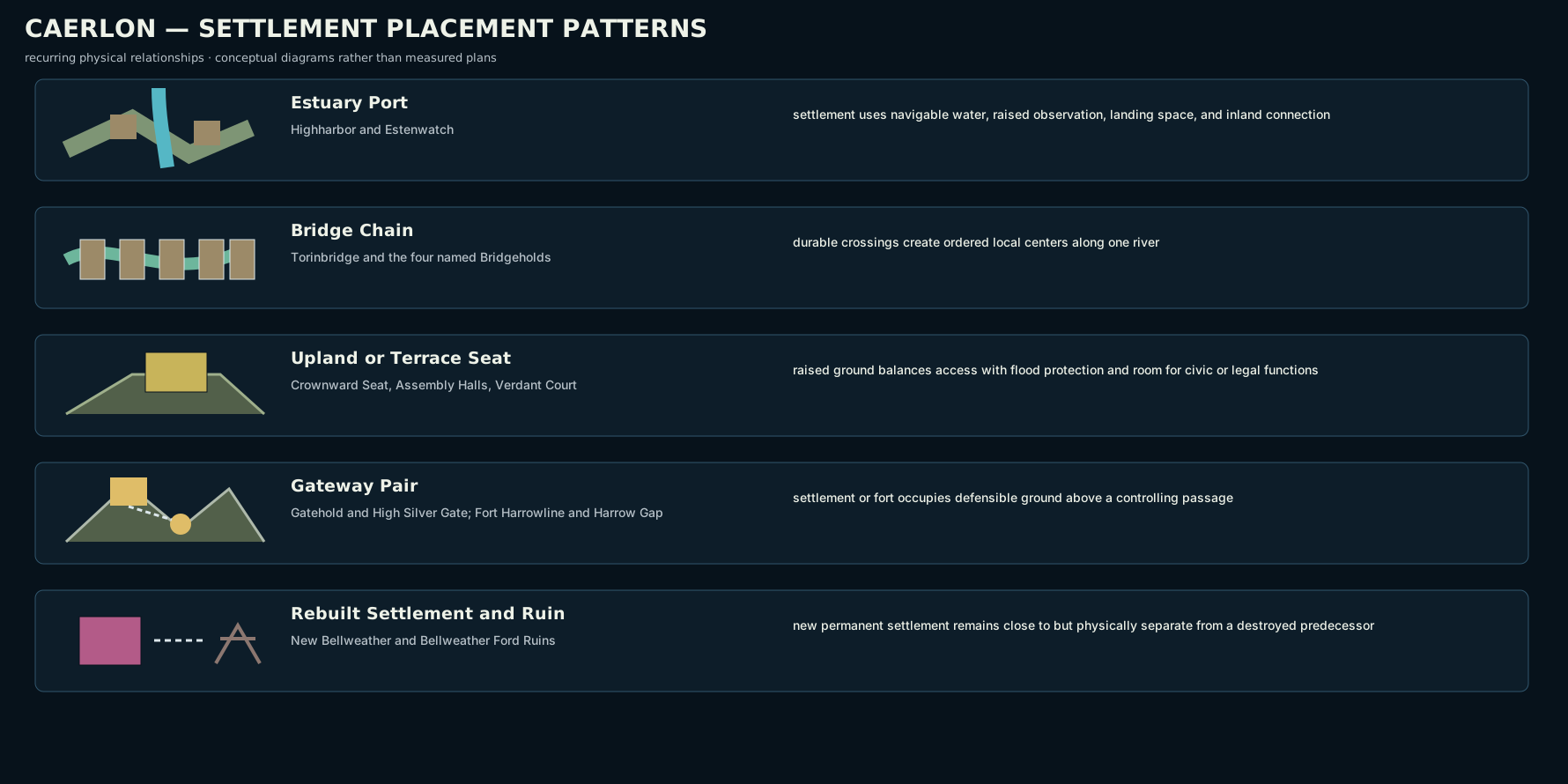
Highharbor and Estenwatch both occupy estuaries, but their scale and purpose differ. Highharbor is a two-bank commercial metropolis. Estenwatch is a fortress-port on one raised headland.
Bridge Chain
The Torin Freeholds use a linear settlement pattern. Each durable crossing creates a local center, while the river and road preserve the order between them.
Upland or Terrace Seat
Crownward Seat, the Assembly Halls, and Verdant Court occupy raised ground close to the systems they serve. Their placement balances access with protection from floodwater and congestion.
Gateway Pair
High Silver Gate and Silveredge Gatehold form a paired landscape: lower pass saddle and higher western settlement ledge. Harrow Gap and Fort Harrowline form another pair: river passage below and fortified observation site above.
Rebuilt Settlement and Ruin
New Bellweather and Bellweather Ford Ruins are two places, not one settlement with an old district. Their separation expresses a practical postwar decision while preserving the old site as a crossing, memorial, and recovery landscape.
Regional Settlement Patterns
| Region | Continent-scale anchors | General pattern |
|---|---|---|
| Crownward Remnant | Crownward Seat | Raised administrative city with archive, ministry, road, ceremonial, and supporting institutional sites |
| Heart Plains | Heartplain Assembly Halls | Dispersed grain and mill communities organized around a central civic settlement |
| Scoured Marches | Fort Harrowline, New Bellweather, Bellweather Ford Ruins, Estenwatch | Fort-and-road reconstruction corridor extending toward a fortress-port |
| Highharbor Coast | Highharbor | Estuary metropolis with quay districts, signal networks, coastal settlements, and working landings |
| Torin Freeholds | Torinbridge and four named Bridgeholds | Ordered linear chain of crossing communities |
| Valenic Compact | Valen Crown Bridge | River-corridor settlements tied to bridges, ferries, towpaths, mills, and flood terraces |
| Estenmark | No numbered anchor | Defensive river-road network of watch towns, fortified farms, fords, and depots |
| Verdant Principalities | Verdant Court | River-terrace court settlement surrounded by estate and woodland communities |
| Silveredge Holds | High Silver Gate and Silveredge Gatehold | Pass settlement paired with distributed signal, mine, refuge, and mountain-hold communities |
| Elderidge Oathlands | No numbered anchor | Decentralized hall, village, ford, shrine, and witness-house pattern |
| Broken Chain Approaches | No numbered anchor | Distributed islet, anchorage, reef-station, quarantine, and patrol network |
A region without a numbered marker is not uninhabited or unimportant. It means that its settlement pattern is too distributed, too local, or better represented on a regional map.
Major Sites and Canonical Parents
Every fixed physical site belongs to one geographic parent.
A quay within Highharbor remains geographically part of Highharbor even when a separate court, temple, guild, or patrol controls its work. The Heartplain Granary Vault belongs to the Assembly Halls settlement even when regional grain authorities govern access. Harrowline Outer Redoubt belongs to the Fort Harrowline complex even when scouts operate beyond the fort.
Political ownership, religious authority, and institutional control do not replace geographic containment.
Settlement Placement in Play
At the table, settlement placement determines what a traveler can reasonably encounter.
A party reaching Highharbor arrives through estuary and port geography. A party approaching Torinbridge must deal with a river crossing and freehold authority. A party reaching the Assembly Halls enters a grain-road and public-meeting settlement. A party traveling to Fort Harrowline enters a controlled frontier approach. A party visiting Bellweather Ford Ruins leaves an inhabited town and travels to a separate damaged site.
Pathfinder Second Edition Remaster mechanics come from the actual scene: urban streets, crowds, bridges, riverbanks, slopes, walls, stairs, weather, difficult terrain, visibility, and hazards. The numbered map establishes where a settlement sits and what surrounds it. A settlement or encounter map establishes the distances, movement, DCs, and tactical details.
Map Scope
This page establishes:
- the stable placement of all sixteen numbered Caerlon sites;
- the difference between core and secondary sites;
- the relationship between settlements, gateways, ruins, supporting sites, and distributed networks;
- the downstream order of the Torin Bridgeholds;
- Crownward Seat above the middle Valen;
- Heartplain Assembly Halls on Assembly Ridge;
- Silveredge Gatehold above High Silver Gate;
- Fort Harrowline above Harrow Gap;
- Estenwatch on the Esten mouth in the Scoured Marches;
- Verdant Court above the middle Greenmantle;
- New Bellweather west of Bellweather Ford Ruins;
- the regional settlement pattern of all eleven Caerlon regions.
It does not establish city districts, street plans, building interiors, local property lines, exact populations, settlement-level travel times, encounter maps, hidden sites, or the full roster of every village and regional landmark.
← Routes, Travel Times, and Navigation · Geography of the Scoured Marches →