Appearance
Caerlon — Rivers, Watersheds, and Wetlands
Caerlon is divided by water as clearly as it is divided by mountains. The Silveredge Arc separates three western drainage systems from the east-flowing River Esten. On the western side, the River Valen, River Torin, and Greenmantle River reach the Sunset Gulf through three distinct mouths. On the eastern side, the Esten crosses central Caerlon, cuts through Harrowline Ridge, and enters the Dread Sea at Estenwatch.
These watersheds explain where large settlements stand, why some crossings matter more than others, and why neighboring communities may belong to different economic and political worlds. A river is not only a line of water. Its valley includes springs, tributaries, floodplains, terraces, marshes, crossings, river towns, and the higher ground from which water drains into it.
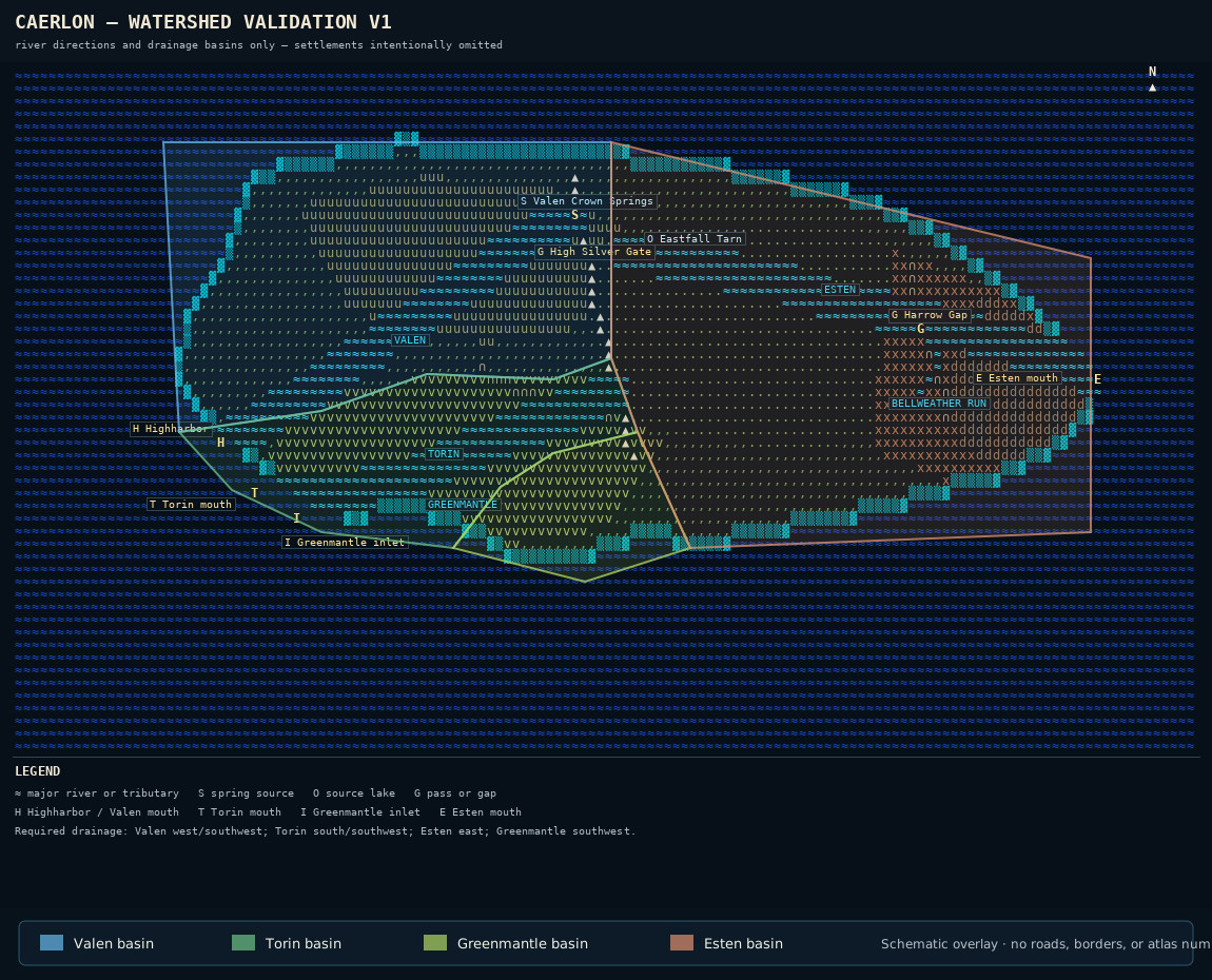
Caerlon’s four principal drainage systems shown over the established watershed-validation geometry. Colors distinguish drainage basins rather than political regions. Settlements and atlas numbers are omitted so the river system remains legible. The schematic uses relative position and is not drawn to a fixed measured scale.
Open the full watershed map · Read the watershed-map description

Reading a Watershed
A watershed is all the land whose water drains toward the same river or outlet. The boundary between watersheds usually follows high ground: a mountain crest, ridge, saddle, or subtle rise across otherwise open country. Two farms may stand only a few miles apart while their rainwater reaches different seas.
Caerlon’s principal divide follows the Silveredge Arc. Water west of the crest enters the Valen, Torin, or Greenmantle systems and ultimately reaches the Sunset Gulf. Water east of the crest enters the Esten system and reaches the Dread Sea. The Elderidge Hills divide parts of the three western basins from one another without forming a second continent-scale wall.
| River system | Source | General flow | Mouth |
|---|---|---|---|
| Valen | Valen Crown Springs on the northwestern Silveredge slopes | West, then southwest | Highharbor estuary and Sunset Gulf |
| Torin | Elderidge–Silveredge Saddle | South, then southwest | Reedgate Marshes and Sunset Gulf |
| Greenmantle | Southern Elderidge Hills | Southwest | Sheltered Sunset Gulf inlet southeast of the Torin mouth |
| Esten | Eastfall Tarn on the eastern Silveredge face | East | Estenwatch and the Dread Sea |
The Four River Systems
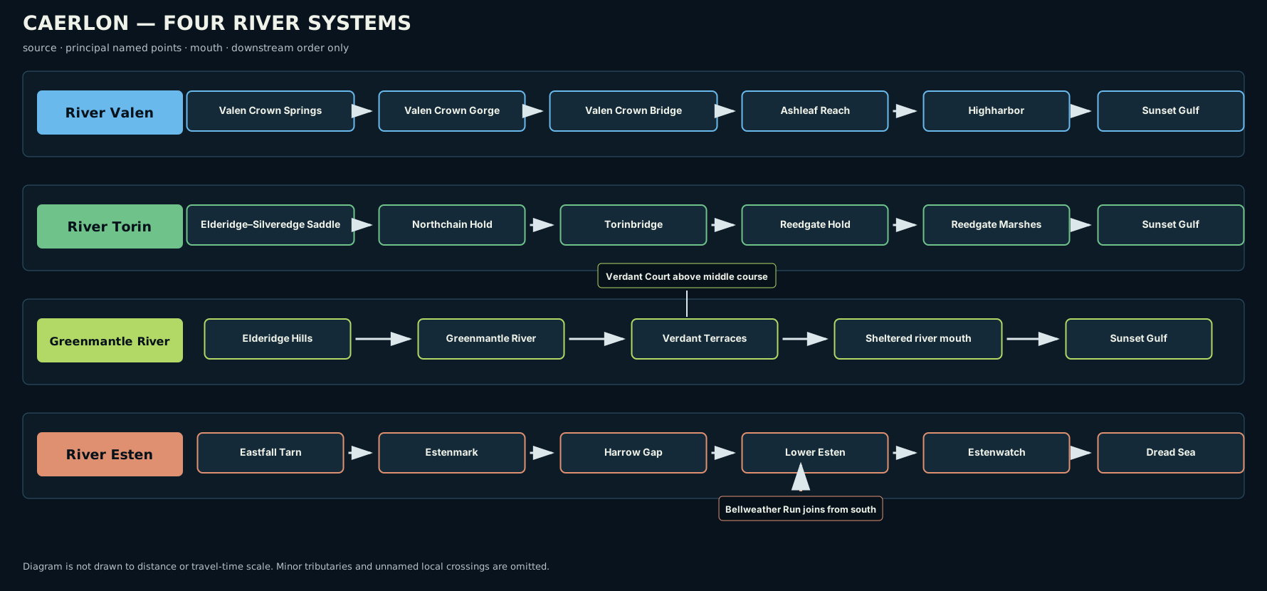
The four major river sequences. The diagram shows downstream order, not distance or travel time.
Open the four-river diagram · Read the diagram description

River Valen
The River Valen rises at Valen Crown Springs on the northwestern slopes of the Silveredge Arc. Its highest channels gather among steep ground before joining in Valen Crown Gorge, where the river turns west through a confined upper valley. The gorge makes the river easy to locate but difficult to leave; travelers following it pass between high sides until the valley broadens.
Valen Crown Bridge stands forty river miles below the springs. The bridge marks the transition between the steep upper river and the more settled middle basin. Below it, the river widens through the Valenic country, receiving smaller streams from the Crownward Uplands and western Silveredge slopes.
The Crownward Seat does not stand on the riverbank. It occupies a raised terrace twelve miles south of the Ashleaf Reach, a navigable middle section of the Valen. Roads and river landings connect the elevated administrative center to the water without placing it inside the ordinary floodplain.
Farther downstream, the river becomes tidal before reaching Highharbor. The city occupies both sides of the estuary. The older city and principal shipyards stand on the downstream right-bank headland, while grain quays and lower warehouses occupy the left-bank flats. The deepwater channel passes between them before opening into the Sunset Gulf.
Valen Flood Country
The upper Valen has little room to spread within the gorge. Floodwater rises quickly against steep banks and moves forcefully through narrow reaches. In the middle basin, the valley broadens and the river can occupy side channels, low fields, mill streams, and seasonally wet ground. Near Highharbor, river flooding meets tides, estuary currents, and coastal weather.
The broadest flood-prone land therefore lies below the gorge and around the lower tidal river rather than at the springs. Raised terraces, old levees, quays, headlands, and local embankments determine which parts of the riverfront remain usable during high water.
River Torin
The River Torin begins in the Elderidge–Silveredge Saddle, where the southern Silveredge slopes and eastern Elderidge Hills create a lower divide between neighboring basins. The river flows south through a narrower upper valley before turning southwest through the Torin Freeholds.
The Torin is organized around a clear downstream sequence of bridge communities. Northchain Hold stands at the first reliable navigation point. Stonewake Hold lies below it, followed by Torinbridge, Lowspan Hold, and Reedgate Hold. The sequence matters because each hold occupies a different part of the river and controls a different crossing or landing.
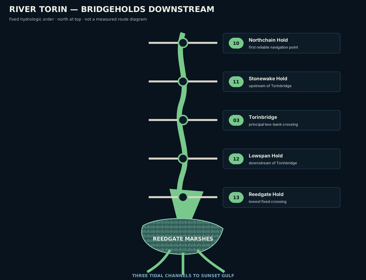
The Torin Bridgeholds in downstream order. The diagram records hydrologic sequence and does not define road distance, jurisdiction, or travel time.
Open the Bridgehold diagram · Read the diagram description

Torinbridge spans both banks of the middle river and is the strongest continent-scale crossing on the Torin. Below it, Lowspan and Reedgate occupy progressively lower reaches. After Reedgate Hold, the river enters the Reedgate Marshes and divides into three tidal channels before reaching the Sunset Gulf.
The Torin mouth lies approximately sixty nautical miles south of Highharbor. It remains distinct from both the Valen estuary and the Greenmantle inlet.
Reedgate Marshes
Reedgate Marshes are the principal named wetland shown on Caerlon’s current continent-scale maps. They form where the lower Torin loses gradient, divides among tidal channels, and meets the low coastal margin. Reed beds, mudflats, wet meadows, shallow pools, raised banks, and shifting channels create a wide transition between river and gulf.
The marshes are not a single impassable bog. Firm islands, natural levees, old embankments, landing mounds, and maintained channels break up the wet ground. Their practical geography changes with river level and tide, so a place that is dry at one season may be cut off at another.
Greenmantle River
The Greenmantle River rises in the southern Elderidge Hills and flows southwest through the Verdant Terraces. It is smaller than the Valen, Torin, and Esten at continent scale, but it gives the Verdant country its own drainage system and its own access to the Sunset Gulf.
The river descends through hill valleys before entering broader cultivated terraces. Its middle course passes below the Verdant Court of Returning Heirs, which stands on a right-bank terrace above the water rather than on the lowest river ground. The stepped surrounding land creates alternating high banks, river benches, orchard slopes, and narrower flood strips.
Near the coast, the Greenmantle reaches a sheltered inlet southeast of the Torin mouth. It does not merge with the Torin delta. The two outlets remain separate even though both enter the Sunset Gulf along Caerlon’s southwestern coast.
The Sheltered Inlet
The Greenmantle inlet is more enclosed than the open Valen estuary and less dispersed than the Reedgate channels. Lower terraces and river flats meet a protected coastal indentation where freshwater, tidal water, and local drainage overlap.
Marsh, reeds, and wet ground occur around the inlet, but they do not form a second wetland region comparable in scale to Reedgate. The defining relationship is separation: Greenmantle water reaches the gulf through its own inlet, preserving a distinct Verdant coastal outlet.
River Esten
The River Esten begins at Eastfall Tarn on the eastern face of the Silveredge Arc. From the tarn, the river descends through the Eastfall Steps, a sequence of ledges, narrow channels, wooded slopes, and short drops that carry water from the mountain face into the upper Esten valley.
The Esten flows east across central Caerlon. High Silver Gate crosses the watershed between the upper Valen and Esten systems, but the river itself remains on the eastern side of the divide. Silveredge Gatehold stands above the western approach to the pass rather than on the Esten bank.
The river broadens through Estenmark and passes north of the Heartplain Assembly Halls. The halls occupy Assembly Ridge, dry ground south of the river and north of the Torin basin. This position keeps the assembly site connected to central Caerlon without placing it inside the Esten floodplain.
Farther east, the river cuts through Harrowline Ridge at Harrow Gap. Fort Harrowline stands on the northern height above the crossing. Below the gap, Bellweather Run joins the Esten from the south. Bellweather Ford Ruins occupy both banks of that tributary before its confluence with the main river, while New Bellweather stands west of the ruins on higher northern ground.
The lower Esten crosses the Scoured Marches and Dread Sea Lowlands before reaching Estenwatch. Because the river flows east, its downstream right bank is the southern bank. Estenwatch stands on the right-bank headland above the lower estuary and commands the clearest recognized entrance from the Dread Sea.
Lower Esten and the Eastern Flats
The Esten’s lower floodplain widens as the river approaches the coast. Tidal flats, low banks, abandoned earthworks, damaged drainage, and old channels make water movement more complicated than the single main line shown on a continent map.
The Scoured Marches do not create a new watershed. They overlay the Esten basin with historical damage. Repaired fields, ruined crossings, blocked ditches, breached embankments, and disturbed riverbanks can change local flooding while the river continues to drain east toward the Dread Sea.
Comparing the Western River Mouths
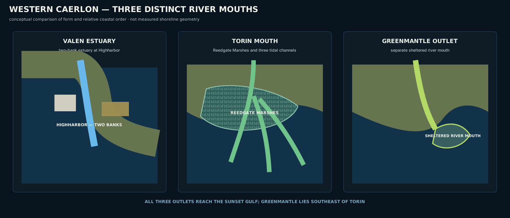
The three western outlets shown at the same conceptual scale. The comparison explains form and relative order rather than measured shoreline distance.
Open the western-mouths comparison · Read the comparison description

The western rivers reach the same gulf in three different ways.
- The Valen forms a major two-bank estuary at Highharbor.
- The Torin divides into three tidal channels through Reedgate Marshes.
- The Greenmantle reaches a separate sheltered inlet southeast of the Torin mouth.
The three outlets remain separate river-to-sea systems, each connecting a different inland basin to the Sunset Gulf.
Tributaries, Floodplains, and Wet Ground
Only the largest rivers and named tributaries appear on the continental map. Smaller streams descend from the Silveredge Arc, Elderidge Hills, Crownward Uplands, Harrowline Ridge, and local rises throughout the Heart Plains. They feed mill channels, irrigation ditches, side valleys, ponds, seasonal wetlands, and minor crossings.
Most of these waters do not require continent-scale names. Their placement follows the watershed around them. A stream west of the Silveredge crest must reach a western basin. Water east of the crest reaches the Esten. Streams in the Elderidge Hills may enter the Valen, Torin, or Greenmantle depending on which side of a local saddle they occupy.
Floodplains are similarly varied. Some are broad agricultural strips; others are narrow shelves confined by hills. Tidal rivers add estuary flats and brackish channels. Wet ground may be permanent, seasonal, or present only during unusually high water. The map distinguishes the major hydrologic structure without implying that every wet field is a marsh or every riverbank floods alike.
Reading Water While Traveling
Flow direction is one of the most reliable ways to orient within Caerlon. Following the Valen downstream leads toward Highharbor and the Sunset Gulf. Following the Torin downstream passes the Bridgeholds in their fixed order before reaching Reedgate Marshes. Following the Greenmantle downstream leads through the Verdant Terraces to its sheltered inlet. Following the Esten downstream leads east through Harrow Gap, the Marches, and Estenwatch to the Dread Sea.
Local signs also reveal a river’s character. A confined rocky channel indicates upper watershed ground. Broad banks, abandoned channels, and low fields indicate a floodplain. Reeds, tidal mud, salt-tolerant vegetation, and reversing currents show that the coast is near. Raised settlement ground, flood marks, ferry stairs, and bridge approaches often reveal the safer crossing before the crossing itself is visible.
Water in Play
At the table, a mapped river does not impose one universal rule along its entire length. A ford, ferry landing, tidal channel, steep gorge, floodplain, and deep estuary create different encounter spaces.
Pathfinder Second Edition Remaster can represent these spaces through aquatic environments, difficult terrain, uneven ground, currents, swimming, falling, drowning, weather, and environmental hazards. The local map determines the actual conditions. A broad river symbol on the continental atlas does not establish the width, depth, current, or crossing difficulty of every reach.
High water can also change an otherwise familiar route. A normal ford may become impassable, a marsh channel may deepen, a low bridge may close, or a bank path may count as difficult terrain. Such changes should be tied to the specific place and conditions rather than applied to an entire watershed.
Map Scope
The watershed map and diagrams on this page establish:
- the four principal drainage systems;
- their confirmed sources, directions, and mouths;
- the Silveredge watershed divide;
- the downstream order of the Torin Bridgeholds;
- the location of Reedgate Marshes;
- Bellweather Run joining the Esten from the south;
- the separation and relative order of the three western river mouths;
- the relationship between the Esten, Harrow Gap, and Estenwatch.
They do not establish exact river widths, depths, seasonal calendars, ordinary travel times, complete tributary networks, bridge engineering, ferry schedules, navigation law, political jurisdiction, or current hazard conditions.
← Terrain, Elevation, and Landforms · Caerlon — Geography and Maps