Appearance
Caerlon — Regions, Boundaries, and Adjacency
Caerlon is commonly divided into eleven major regions. These regions help people describe where they are, which roads and rivers shape local life, what kind of authority they expect to meet, and how the land changes around them. They are not eleven perfectly surveyed provinces. Several are geographic and cultural regions whose political authorities overlap, compete, or stop short of the region’s full extent.
The map fixes their continent-scale placement and the regions that directly meet. A regional boundary may follow a mountain foot, watershed divide, river corridor, coastal margin, or visible change in settlement and land use. In other places it is a transition several miles wide. Local property lines, municipal borders, military districts, toll jurisdictions, and sanctuary limits can cross the broader regional lines shown here.
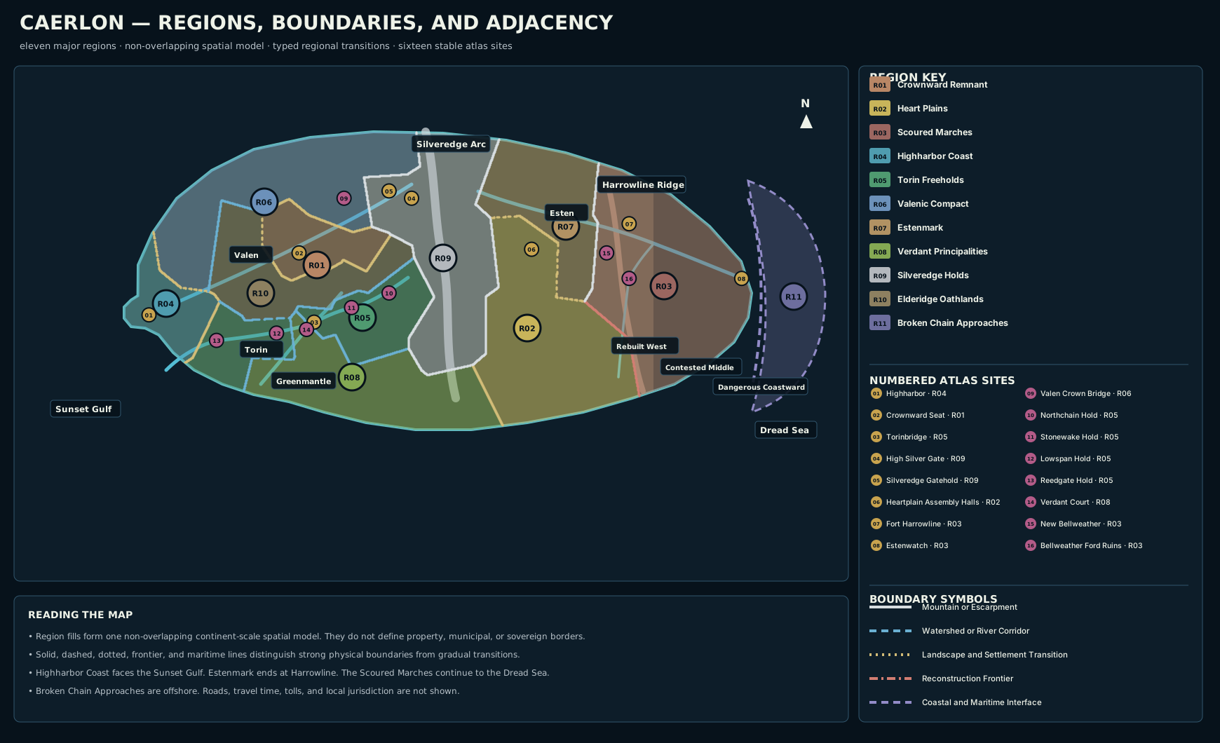
Caerlon’s eleven major regions over the established coastline and river geometry. Region colors show generalized geographic extent. Boundaries are regional transitions rather than universal political frontiers. Numbered site markers retain the existing Caerlon atlas sequence.
Open the full regional map · Read the regional-map description

How Regional Boundaries Work
A Caerlonian region is recognized by several kinds of evidence at once.
Physical evidence includes mountain slopes, river valleys, watersheds, marsh margins, coastal headlands, and the broad change from uplands to plains.
Settlement evidence includes the kinds of towns, crossings, fields, forts, quays, and public buildings that repeat across an area. The Torin Bridgeholds identify the Torin Freeholds as clearly as the river itself. Fort lines and resettled villages identify the western Scoured Marches even where the terrain resembles Estenmark.
Customary evidence includes names used by residents, market relationships, pilgrimage habits, legal expectations, and the places where travelers begin to seek different witnesses, permits, escorts, or local knowledge.
Historical evidence matters most in the east. The boundary between Estenmark and the Scoured Marches is not only a natural line. Harrowline Ridge, Harrow Gap, fortifications, retreat routes, and postwar resettlement all contribute to the transition.
A regional line on this map therefore answers, “Which broad part of Caerlon is this?” It does not by itself answer, “Which authority owns this field?” or “Whose law applies on this bridge?”
Continental Arrangement
Caerlon’s regional pattern can be read from west to east.
The Highharbor Coast forms the western maritime entrance around the Valen estuary and Sunset Gulf. Inland from it, the Valenic Compact, Crownward Remnant, Elderidge Oathlands, Torin Freeholds, and Verdant Principalities divide the western river, hill, terrace, and cultivated country.
The Silveredge Holds form a north–south mountain region between western Caerlon and the central basin. The Heart Plains occupy the broad country east and southeast of Silveredge. Estenmark follows the upper and middle Esten corridor from the eastern Silveredge approaches toward Harrowline.
The Scoured Marches begin along the Harrowline transition and extend east to the Dread Sea coast. The Broken Chain Approaches are the maritime region beyond and along that coast: approach waters, patrol zones, quarantine sites, islands, wreck fields, and the westward end of the Broken Chain route.
Western Caerlon
Highharbor Coast
The Highharbor Coast surrounds the lower Valen and its Sunset Gulf estuary. It is Caerlon’s principal western maritime region, not an eastern Dread Sea coast. Highharbor stands on both banks of the estuary, while the surrounding region includes tidal flats, headlands, lower river settlements, fisheries, quays, shipyards, coastal roads, and communities tied to overseas trade.
Its inland boundary is recognizable where tidal and coastal ground gives way to the Valenic river corridor, Elderidge foothills, and the northern edge of the Torin country. The boundary is irregular because estuary traffic and coastal settlement extend inland along navigable water.
Direct neighbors: Valenic Compact, Elderidge Oathlands, Torin Freeholds.
Valenic Compact
The Valenic Compact occupies the River Valen corridor from the lower inland reaches toward Valen Crown Gorge and the western Silveredge approaches. The region includes floodplain farms, river terraces, towpaths, bridge approaches, mill settlements, warehouses, and communities whose daily geography follows the Valen.
The Compact meets the Highharbor Coast where the lower river becomes tidal. It meets the Crownward Remnant along the Ashleaf Reach and the terrace country south of the middle Valen. Its southern edge follows the transition into Elderidge hill country. Its eastern edge reaches the western Silveredge foot and the upper Valen approaches.
Direct neighbors: Highharbor Coast, Crownward Remnant, Elderidge Oathlands, Silveredge Holds.
Crownward Remnant
The Crownward Remnant occupies raised western-central country south of the middle Valen and west of Silveredge. Crownward Seat stands above the river rather than on its bank. The region’s broad geography is one of terraces, uplands, administrative settlements, surviving estates, archive towns, quarries, and roads descending toward river landings.
The Valenic Compact lies north and northwest across the middle-Valen terrace transition. Elderidge broken hill country lies west and southwest. The Silveredge Holds rise along the eastern edge. High Silver Gate is reached through Silveredge territory rather than by treating the Crownward Remnant and Heart Plains as directly adjacent.
Direct neighbors: Valenic Compact, Elderidge Oathlands, Silveredge Holds.
Elderidge Oathlands
The Elderidge Oathlands occupy the broken interior hills between the western river corridors. Their terrain is lower than Silveredge but more enclosed than the Crownward Uplands or Heart Plains. Short ridges, saddles, wooded valleys, old boundary stones, village courts, and local record houses give the region a strongly local geography.
The Oathlands meet the Highharbor Coast along the western foothill transition, the Valenic Compact along the southern Valen watershed, the Crownward Remnant along the upland-hill break, and the Torin Freeholds along the Torin headwaters and descending valleys.
Direct neighbors: Highharbor Coast, Valenic Compact, Crownward Remnant, Torin Freeholds, Verdant Principalities, Silveredge Holds.
Torin Freeholds
The Torin Freeholds follow the River Torin from its Elderidge–Silveredge source area through the Bridgehold sequence to Reedgate Marshes and the Sunset Gulf. Northchain Hold, Stonewake Hold, Torinbridge, Lowspan Hold, and Reedgate Hold establish a fixed downstream order within the region.
The Freeholds meet Highharbor’s coastal region along the coast north of the Reedgate margin. Elderidge lies to the north and northwest. The Verdant Principalities begin across the Torin–Greenmantle watershed and the southern terrace transition. A short eastern boundary reaches the Silveredge foothills near the Torin source.
Direct neighbors: Highharbor Coast, Elderidge Oathlands, Verdant Principalities, Silveredge Holds.
Verdant Principalities
The Verdant Principalities occupy the southwestern terraces drained by the Greenmantle River. Their regional identity follows descending cultivated land, orchard and garden country, estate roads, river benches, old courts, and the separate Greenmantle outlet on the Sunset Gulf.
The northern boundary follows the transition from Torin country into the Greenmantle basin. The eastern boundary climbs toward the southern Silveredge foothills. The northeastern edge meets the southern Heart Plains where terrace country gives way to broad open farmland.
Direct neighbors: Elderidge Oathlands, Torin Freeholds, Silveredge Holds, Heart Plains.
The Silveredge Divide
Silveredge Holds
The Silveredge Holds occupy the principal mountain arc from the northern heights through High Silver Gate to the southern foothills. The region includes mountain valleys, hold settlements, mines, pass approaches, beacon sites, defensive ledges, and the high watershed separating the western river systems from the Esten basin.
Silveredge borders more regions than any other land region because it forms the long divide at the center of Caerlon. Valenic, Crownward, Torin, and Verdant country approach from the west and southwest. Estenmark and the Heart Plains lie to the east.
High Silver Gate and Silveredge Gatehold stand within this mountain region. The gate connects western and eastern Caerlon, but the existence of a pass does not erase the Silveredge region between them.
Direct neighbors: Valenic Compact, Crownward Remnant, Elderidge Oathlands, Torin Freeholds, Verdant Principalities, Heart Plains, Estenmark.
Central and Eastern Caerlon
Heart Plains
The Heart Plains occupy the broad central basin east and southeast of Silveredge. The region is defined by open agricultural land, long sightlines, river-fed drainage, assembly settlements, storage centers, market roads, and the ability to support large populations.
Its western boundary follows the eastern Silveredge foot. The Verdant terrace transition forms the southwest boundary. Estenmark lies north and northeast along the Esten corridor. The eastern boundary reaches Harrowline and the western edge of the Scoured Marches.
Heartplain Assembly Halls stand on Assembly Ridge south of the Esten and north of the Torin basin. Their placement reflects the region’s central position without putting the halls inside either river’s floodplain.
Direct neighbors: Verdant Principalities, Silveredge Holds, Estenmark, Scoured Marches.
Estenmark
Estenmark follows the upper and middle River Esten from Eastfall Tarn and the eastern Silveredge approaches toward Harrowline. It is a river-march region of floodplain settlements, fortified crossings, supply country, return villages, estates, and roads oriented toward the east.
The Silveredge Holds form its western boundary. The Heart Plains lie south of the principal Esten corridor. Harrowline Ridge and Harrow Gap establish the clearest transition into the Scoured Marches.
Estenmark does not extend to the Dread Sea coast. The lower Esten, Bellweather country, Estenwatch, and the coastward lowlands lie within the Scoured Marches.
Direct neighbors: Silveredge Holds, Heart Plains, Scoured Marches.
Scoured Marches
The Scoured Marches extend from the Harrowline transition to the Dread Sea. The region crosses several landforms: ridge approaches, Esten floodplain, damaged agricultural country, lower hills, wetlands, abandoned estates, and the Dread Sea Lowlands. Its unity is historical and practical rather than geological.
The Marches meet Estenmark at Harrowline Ridge and Harrow Gap. South of the Esten corridor, they meet the eastern Heart Plains along the Harrowline transition and the beginning of invasion-scarred country. Their eastern edge is the Dread Sea coast and the maritime threshold of the Broken Chain Approaches.
The Marches contain three ordered subregions:
- Western Rebuilt Marches — functioning settlements, maintained patrol links, repaired fields, and the strongest public services.
- Contested Middle Marches — incomplete control, irregular settlement, damaged roads, uncertain records, and wider gaps between reliable shelters.
- Dangerous Coastward Marches — the public name for the canonical Coastward Marches, the deepest mainland approach to the Dread Sea and the area with the strongest exposure to ruined coastal works and incomplete reclamation.
Fort Harrowline stands at the western boundary system. New Bellweather and Bellweather Ford lie farther east along Bellweather Run. Estenwatch occupies the lower Esten headland at the coast.
Direct neighbors: Heart Plains, Estenmark, Broken Chain Approaches.
Broken Chain Approaches
The Broken Chain Approaches are Caerlon’s eastern maritime region. They begin at the Dread Sea shore and extend into the patrol waters, islands, quarantine sites, wreck fields, signal positions, and approach routes leading toward the Broken Chain.
This region is not a strip of mainland replacing the Dread Sea Lowlands. The lowlands and Estenwatch remain part of the Scoured Marches. The Approaches begin where coast, estuary, islands, and controlled waters create a distinct maritime environment.
Direct neighbor: Scoured Marches.
Numbered Atlas Sites by Region
The map retains the established 01–16 atlas sequence. Each marker lies inside one mapped region rather than merely appearing near its regional label.
| No. | Site | Region |
|---|---|---|
| 01 | Highharbor | Highharbor Coast |
| 02 | Crownward Seat | Crownward Remnant |
| 03 | Torinbridge | Torin Freeholds |
| 04 | High Silver Gate | Silveredge Holds |
| 05 | Silveredge Gatehold | Silveredge Holds |
| 06 | Heartplain Assembly Halls | Heart Plains |
| 07 | Fort Harrowline | Scoured Marches |
| 08 | Estenwatch | Scoured Marches |
| 09 | Valen Crown Bridge | Valenic Compact |
| 10 | Northchain Hold | Torin Freeholds |
| 11 | Stonewake Hold | Torin Freeholds |
| 12 | Lowspan Hold | Torin Freeholds |
| 13 | Reedgate Hold | Torin Freeholds |
| 14 | Verdant Court of Returning Heirs | Verdant Principalities |
| 15 | New Bellweather | Scoured Marches |
| 16 | Bellweather Ford Ruins | Scoured Marches |
Regional Adjacency
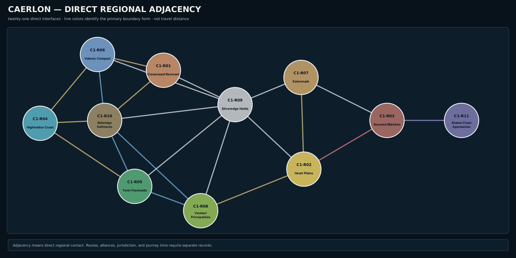
Lines show direct regional adjacency. They do not represent roads, travel times, alliances, or political control.
Open the adjacency diagram · Read the adjacency-diagram description

| Region | Directly adjacent regions |
|---|---|
| Highharbor Coast | Valenic Compact, Elderidge Oathlands, Torin Freeholds |
| Valenic Compact | Highharbor Coast, Crownward Remnant, Elderidge Oathlands, Silveredge Holds |
| Crownward Remnant | Valenic Compact, Elderidge Oathlands, Silveredge Holds |
| Elderidge Oathlands | Highharbor Coast, Valenic Compact, Crownward Remnant, Torin Freeholds, Verdant Principalities, Silveredge Holds |
| Torin Freeholds | Highharbor Coast, Elderidge Oathlands, Verdant Principalities, Silveredge Holds |
| Verdant Principalities | Elderidge Oathlands, Torin Freeholds, Silveredge Holds, Heart Plains |
| Silveredge Holds | Valenic Compact, Crownward Remnant, Elderidge Oathlands, Torin Freeholds, Verdant Principalities, Heart Plains, Estenmark |
| Heart Plains | Verdant Principalities, Silveredge Holds, Estenmark, Scoured Marches |
| Estenmark | Silveredge Holds, Heart Plains, Scoured Marches |
| Scoured Marches | Heart Plains, Estenmark, Broken Chain Approaches |
| Broken Chain Approaches | Scoured Marches |
Shared Waters and Major-Feature Interfaces
Regional adjacency also includes shared waters and physical features. These relationships are recorded separately from land-region neighbor counts.
| Region | Principal shared waters or features |
|---|---|
| Highharbor Coast | Sunset Gulf; lower River Valen |
| Valenic Compact | River Valen; Valen Crown Gorge; western Silveredge approaches |
| Crownward Remnant | Crownward Uplands; middle-Valen terrace country; western Silveredge foot |
| Elderidge Oathlands | Elderidge Hills; Torin and Greenmantle headwaters; Elderidge–Silveredge Saddle |
| Torin Freeholds | River Torin; Reedgate Marshes; Sunset Gulf |
| Verdant Principalities | Greenmantle River; Verdant Terraces; Sunset Gulf |
| Silveredge Holds | Silveredge Arc; High Silver Gate; principal watershed divide |
| Heart Plains | Heart Plains basin; Assembly Ridge; southern Esten drainage |
| Estenmark | upper and middle River Esten; eastern Silveredge approaches; Harrowline |
| Scoured Marches | lower River Esten; Harrowline; Dread Sea Lowlands; Dread Sea Coast |
| Broken Chain Approaches | Dread Sea; Broken Chain; quarantine islets and patrol waters |
Types of Regional Boundary
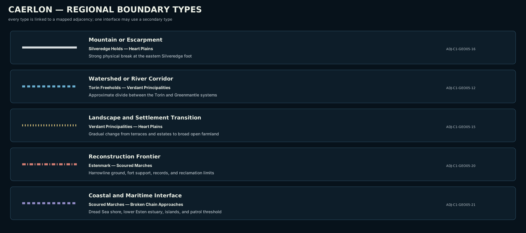
Caerlon’s regional boundaries use several forms. A single regional interface may combine more than one form.
Open the boundary-type diagram · Read the boundary-type description

Mountain and Escarpment Boundaries
Silveredge provides the clearest example. The mountain foot, high valleys, pass approaches, and watershed crest distinguish the Holds from western river country and the central basin. Harrowline provides a lower but historically important eastern example.
Watershed and River-Corridor Boundaries
The Valenic Compact, Torin Freeholds, and Verdant Principalities are organized around separate drainage systems. Their regional edges often follow low divides, changes in river access, or the point where settlement patterns stop facing one river and begin facing another.
Landscape and Settlement Transitions
The line between the Heart Plains and neighboring regions is often recognized through changing land use and sightlines rather than a wall or river. Broad fields narrow into terrace country, hills, mountain approaches, or damaged Marcher land.
Reconstruction Frontiers
The eastern boundaries include historical conditions that can move locally without changing the continent-scale region. Repaired drainage, occupied settlements, fort support, patrol access, and reliable records distinguish the western Scoured Marches from deeper zones.
Coastal and Maritime Interfaces
Highharbor’s inland edge follows the point where tidal-coastal settlement gives way to river and hill country. The Scoured Marches–Broken Chain interface follows the Dread Sea shore, lower Esten estuary, offshore islands, and controlled approach waters.
Older Maps and Regional Names
Older Caerlonian records and broad public accounts use several names that remain understandable but do not control this map.
| Older or alternate name | Current regional use |
|---|---|
| Crownward Heart | Crownward Remnant |
| Valenic River Corridor | Valenic Compact |
| Torin Riverlands | Torin Freeholds |
| Verdant Expanse | Verdant Principalities as a region; Verdant Terraces or Verdant Expanse for physical landscape |
| Silveredge Mountains | Silveredge Arc or Silveredge Mountains for the landform; Silveredge Holds for the region |
| Dread Sea Coast | The physical eastern coastline, chiefly within the Scoured Marches; not a twelfth major region |
A traveler may still hear any of these names. The distinction matters when a speaker is referring to land, a political network, or a regional identity.
Recognizing a Regional Crossing
Regional crossings are often recognized gradually.
A traveler leaving Highharbor may notice tidal warehouses and salt-weathered buildings giving way to inland river landings before anyone announces the Valenic Compact. Someone moving from Crownward toward Silveredge sees terraces narrow, slopes steepen, and mountain authority become more visible. A traveler east from the Heart Plains finds open fields interrupted by Harrowline ground, forts, warning systems, damaged drainage, and the records of resettlement.
Local markers may include carved boundary stones, bridge notices, market seals, patrol boards, shrine customs, road maintenance changes, ferry rules, or a new pattern of public questions. These markers reflect local authority and custom; they do not all stand on the exact regional line.
Regions in Play
Regional adjacency helps determine what is plausible on a local or continental map. A journey from the Crownward Remnant to the Heart Plains passes through the Silveredge Holds rather than crossing an invisible direct border. Travel from Estenmark to the coast enters the Scoured Marches before reaching Estenwatch. A vessel departing mainland Caerlon for the Broken Chain enters the Approaches from the Marcher coast.
Pathfinder Second Edition Remaster does not assign a mechanical effect to crossing a named region. Mechanics come from the actual terrain and scene: mountain slopes, rivers, marshes, weather, fortifications, damaged ground, visibility, and local hazards. A regional line helps the table choose the relevant environment, customs, and likely services without replacing a local encounter map.
Map Scope
The regional map and adjacency diagram establish:
- the continent-scale position of all eleven major Caerlon regions;
- which regions directly meet;
- the mountain, river, landscape, reconstruction, and maritime forms of their boundaries;
- the west-to-east order of the Scoured Marches subregions;
- Highharbor Coast on the Sunset Gulf;
- the Dread Sea coast within the Scoured Marches rather than as a twelfth region;
- Broken Chain Approaches as a maritime region beyond the mainland;
- the regional assignment of Caerlon’s sixteen numbered atlas sites;
- the three Scoured Marches subregions as internal west-to-east bands;
- principal region-to-water and region-to-feature interfaces.
They do not establish cadastral property lines, municipal borders, polity sovereignty, road geometry, travel time, toll jurisdiction, military districts, sanctuary limits, local encounter maps, or the exact line of every field and village boundary.
← Climate, Weather, and Seasons · Caerlon — Geography and Maps