Appearance
Caerlon — Climate, Weather, and Seasons
Caerlon is broadly temperate, but it does not experience one uniform climate. The Sunset Gulf moderates the western coast and supplies much of western Caerlon’s ordinary rain. The Silveredge Arc lifts that moist air, holds snow at high elevation, and creates a partial rain shadow east of the crest. The Heart Plains experience stronger seasonal contrasts than the coast, while the Dread Sea exposes eastern Caerlon to fog, squalls, and powerful storm fronts.
The result is a continent where weather changes with elevation, exposure, and watershed. Highharbor can be wet and mild while High Silver Gate is closed by snow. The Heart Plains can be dry enough for dust while the lower Esten is rising. A Dread Sea gale may batter Estenwatch without reaching the western river country at full strength.
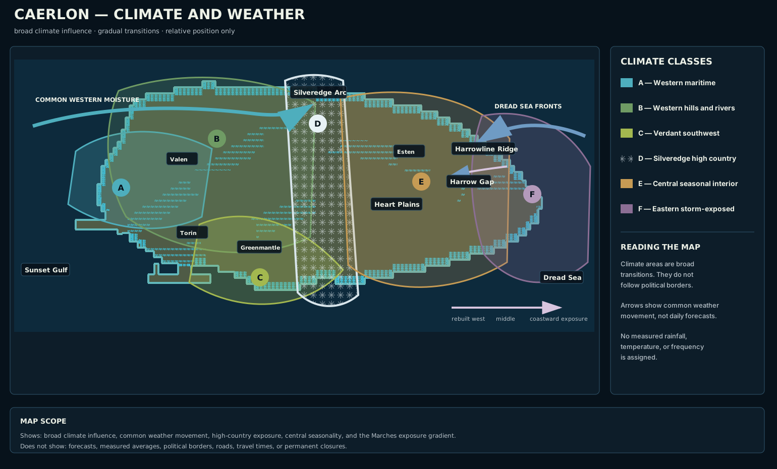
Caerlon’s major climate influences shown across its coastline, rivers, highlands, and watershed divide. The colored areas are broad climate classes with gradual transitions, not political regions or fixed weather boundaries. The schematic uses relative position and is not drawn to a fixed measured scale.
Open the full climate map · Read the climate-map description

What Shapes Caerlon’s Weather
Four physical forces organize the continent’s climate.
The Sunset Gulf keeps the western coast milder than the interior and sends rain, sea fog, and coastal storms into Highharbor and the lower western river valleys. Ordinary western weather often moves inland from the gulf before weakening against higher ground.
The Silveredge Arc is Caerlon’s principal weather divide as well as its watershed divide. Moist air rises along its western approaches, cools, and releases rain or snow. The highest ground holds snow longer than surrounding regions. East of the crest, descending air is often drier, though the central plains remain fertile through seasonal rain, rivers, groundwater, and cultivated drainage.
The broad central basin allows heat, cold, and wind to travel farther than they do among the western hills. The Heart Plains therefore experience warm summers, cold winter spells, spring mud, long sightlines, and strong thunderstorms.
The Dread Sea sends weather against the eastern coast from the opposite direction. Sea fog, hard squalls, and autumn or winter gales strike Estenwatch, the Dread Sea Lowlands, and the coastward Marches most directly. Some fronts push inland through the Esten valley and Harrow Gap.
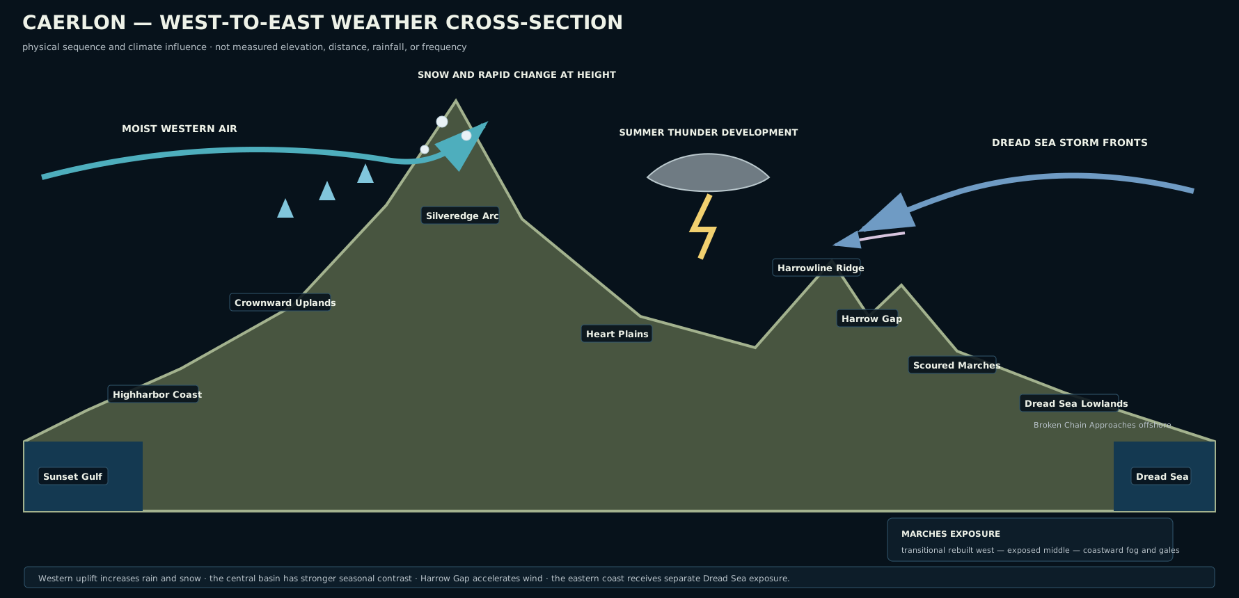
The cross-section explains the main weather relationships. It does not show measured elevation, rainfall totals, or storm frequency.
Open the weather cross-section · Read the cross-section description

Regional Climate at a Glance
| Area | General character | Common seasonal concerns |
|---|---|---|
| Highharbor Coast and lower Valen | Mild maritime influence, frequent cloud, sea fog, rain fronts, salt wind | Estuary fog, winter rain, coastal gales, storm tides |
| Crownward Uplands and Valenic country | Temperate uplands and river valleys with moderate rain and cooler exposed ground | Spring runoff, hill fog, wet roads, late frost on raised land |
| Elderidge and Torin country | Broken hills and sheltered valleys with sharp local differences | Valley fog, sudden downpours, swollen tributaries, frost in shaded hollows |
| Verdant Terraces | Caerlon’s mildest broad cultivated zone, with a long growing season | Summer heat, late dry spells, orchard frost, autumn rain |
| Silveredge high country | Cold, exposed, and changeable, with persistent snow at elevation | Snowfall, ice, avalanche or rockfall weather, high wind, pass closure |
| Heart Plains | Strong seasonal contrast, open wind, warm summers, frosty winters | Spring mud, summer thunderstorms, drought pockets, harvest storms |
| Estenmark and Harrowline | Transitional and exposed, with weather funneled through the Esten corridor | Freeze-thaw damage, high river stages, gap winds, east-moving or west-moving fronts |
| Scoured Marches and Dread Sea Lowlands | Wind-exposed eastern country with coastal moisture and uneven shelter | Fog, squalls, winter gales, flooding in damaged drainage, localized magical weather |
| Broken Chain Approaches | Maritime exposure with rapid changes and limited shelter | Sea fog, crosswinds, rough water, storm surge, visibility loss |
Western Maritime Caerlon
Highharbor and the Lower Valen
Highharbor’s position on the Valen estuary gives it both river weather and sea weather. Fog forms when cool air settles over warmer water or moist sea air moves across the estuary. The thickest fog often affects the lower quays, ferry approaches, and channel markers before it reaches the raised headlands.
Western rain fronts can last for hours or days without becoming violent. Roofs, drains, quays, and warehouses are built around persistent wet weather rather than constant catastrophe. Stronger gulf storms bring higher tides, dangerous harbor chop, and wind that makes exposed towers and cranes difficult to use.
Winter is usually wetter and milder here than in the Heart Plains or Silveredge Holds. Snow may fall, but long-lasting lowland snow is less dependable than rain, sleet, and cold fog.
Crownward and Valenic Country
The Crownward Uplands receive more wind and cooler nights than the lower Valen. Raised terraces can remain firm while riverside ground is wet, but exposed roads are vulnerable to crosswinds and sudden showers. Hill fog commonly gathers around shallow valleys and quarry country.
The middle Valen has a recognizable flood season tied to mountain runoff and widespread spring rain. Local flooding depends on the reach: confined upper channels rise quickly, while wider middle and lower reaches spread across side channels and low fields.
Elderidge, Torin, and the Verdant Southwest
The Elderidge Hills create many small weather pockets. A sheltered valley may be calm while the next ridge is windy. Cold air settles into shaded hollows, morning fog collects along streams, and short downpours can raise tributaries before the main river responds.
The Torin basin shares this local variability. Upper reaches are cooler and more confined. The middle Bridgeholds experience river fog, rain-driven rises, and occasional winter ice. Reedgate Marshes respond to river level, tide, and coastal weather at the same time; rain upstream can enlarge the marsh even when the immediate coast is clear.
The Verdant Terraces are milder and warmer than most of inland Caerlon. Their descending southwestern position supports orchards, gardens, vineyards, estate crops, and a long growing season. Summer can become hot and dry on exposed terraces, while lower valleys remain humid. Frost is most damaging when cold air settles into orchard hollows after early growth has begun.
The Greenmantle inlet receives sheltered coastal weather. It is less exposed than the open Highharbor estuary, but fog and still humid air can linger around the lower river and inlet.
Silveredge Weather
The Silveredge Arc produces Caerlon’s most demanding ordinary weather. Conditions change rapidly with height and exposure. Rain in the western foothills can become sleet or snow near the crest, and a clear lowland morning does not guarantee a safe pass.
Snow collects on high faces, shaded gullies, and the approaches above the principal valleys. Wind can scour one ledge bare while burying another. Freeze-thaw cycles loosen stone, weaken retaining walls, and create ice where meltwater crosses road or stair.
High Silver Gate is lower than the surrounding peaks but remains vulnerable to cloud, wind, snow, and sudden visibility loss. Silveredge Gatehold sits above the western approach and can observe weather moving toward the pass, though local cloud can hide the saddle from both sides.
Mountain closure is often caused by several conditions together rather than snow depth alone: wind, ice, unstable slopes, falling stone, poor visibility, and the inability to reach shelters safely.
The Heart Plains
The Heart Plains have Caerlon’s broadest sky and strongest interior seasonal rhythm. With fewer hills to break the wind, fronts can be seen from far away and can cross large areas quickly.
Spring brings soft ground, full drainage ditches, river-fed fog, and repeated road damage where carts use wet routes too early. Summer brings heat, long daylight, and thunderstorms that build over warm open ground. A storm may be visible for hours before it arrives, but its rain, hail, lightning, and wind can still strike suddenly.
Dry summer intervals are normal, but prolonged heat can harden fields, lower minor streams, and produce dust along heavily used roads. The plains are fertile rather than arid; drought is a seasonal risk, not their defining condition.
Autumn is the principal harvest period and often provides some of the clearest travel intervals. It also brings harvest storms capable of flattening grain, damaging roofs, and turning field roads into mud. Winter is colder than the western coast, with frost, occasional snow, frozen ruts, and open winds that make exposed travel more difficult than the temperature alone suggests.
Estenmark, Harrowline, and the Eastern Marches
Estenmark lies between the Silveredge interior and the exposed east. Weather can arrive from either direction. Western fronts cross the Heart Plains, while Dread Sea fronts move inland along the lower Esten. The Esten corridor can therefore experience rapid changes in wind and pressure.
Harrow Gap concentrates moving air. Strong winds through the gap can be more dangerous than conditions on the surrounding lowlands, especially for high-sided wagons, exposed bridge approaches, signal platforms, and travelers on narrow ground.
The Scoured Marches share the eastern climate of the Esten basin and Dread Sea Lowlands, but exposure increases toward the coast. The western rebuilt Marches remain transitional: Heart Plains and Estenmark fronts still influence them, Harrowline offers some shelter, and repaired drainage reduces ordinary flood risk. The middle Marches are more exposed, with fewer dependable windbreaks, damaged watercourses, and long stretches where shelter is uncertain. The coastward Marches receive the strongest Dread Sea fog, squalls, onshore wind, and winter gales.
Historical damage changes how weather affects the ground without creating a separate climate. Broken drainage, abandoned embankments, denuded slopes, ruined roofs, and compacted military roads can turn ordinary rain into local flooding or erosion.
Some marked battle sites experience publicly documented magical weather: ash-bearing rain, abrupt stillness, persistent fog, or isolated warmth or cold. These effects are local rather than seasonal and should not be treated as the normal weather of the entire Marches.
Estenwatch and the Dread Sea Coast
Estenwatch receives the strongest direct maritime exposure in mainland Caerlon. Sea fog can hide the lower estuary, while headland winds remain strong above it. Squalls may arrive quickly from the Dread Sea and move inland along the Esten before weakening.
Autumn and winter bring the most persistent coastal gales. Spring storms are often wetter, while summer squalls are shorter and can include lightning. Storm surge and river flooding can combine around the estuary, especially when strong onshore winds resist the Esten’s outflow.
The Seasonal Cycle
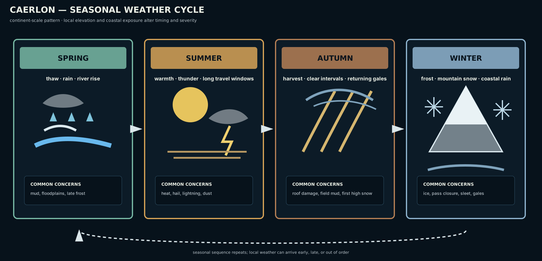
The seasonal cycle summarizes common patterns across Caerlon. Local elevation and coastal exposure can shift the timing or severity of any event.
Open the seasonal-cycle diagram · Read the seasonal-cycle description

Spring: Thaw, Rain, and Rising Rivers
Spring begins unevenly. Low western ground may soften while Silveredge snow remains deep. Mountain and hill runoff combines with seasonal rain, raising the Valen, Torin, Greenmantle, and Esten. Reedgate Marshes expand, ferry approaches change, and low roads become unreliable.
Late frost remains a risk in the Crownward Uplands, Elderidge hollows, Heart Plains, and eastern interior. A warm interval followed by a clear cold night can damage early growth even after winter appears finished.
Summer: Heat, Thunder, and Long Travel Windows
Summer provides the longest daylight and generally the driest roads, especially after spring ground has firmed. The Heart Plains and Verdant Terraces can become hot, while the Highharbor Coast remains moderated by sea air.
Thunderstorms are most common over the central interior and eastern ridges. They bring sudden wind, lightning, hail, and intense rain. Coastal fog can persist even during warm weather when sea and air temperatures differ.
Autumn: Harvest, Clear Intervals, and Returning Gales
Early autumn often combines stable weather, firm ground, and cool nights, making it the most reliable broad weather window for travel. Harvest traffic fills roads and river landings.
As autumn advances, coastal storms strengthen, rain fronts last longer, and the first lasting snow reaches high elevation. Dread Sea gales become more frequent, and western gulf storms can interrupt shipping and estuary work.
Winter: Frost, Snow, Rain, and Closure
Winter divides Caerlon by elevation and distance from the sea. Highharbor and the western coast are often cold, wet, and windy rather than deeply frozen. The Heart Plains and Esten interior experience harder frost, occasional snow, and frozen road surfaces. The Silveredge Holds face sustained snow, ice, and repeated pass closures.
The Dread Sea coast remains storm-exposed. Cold rain, sleet, sea fog, and gales are common concerns even when snow does not remain on the lowlands.
Reading the Weather While Traveling
Caerlonians rarely rely on one sign. Travelers compare the sky, wind, water, local notices, and the behavior of experienced workers.
Useful public signs include:
- a cloud cap forming on Silveredge peaks, often warning of worsening pass conditions;
- a sudden wind through Harrow Gap before a larger eastern or western front;
- the Valen or Esten rising before rain reaches downstream settlements;
- fog thickening first over the Highharbor estuary, Reedgate channels, or lower Esten;
- dark anviled clouds over the Heart Plains, warning of thunder, hail, and lightning;
- marsh water backing into side channels during a strong tide or onshore wind;
- gulls and harbor craft moving inland before a coastal squall;
- frost remaining in Elderidge hollows after open slopes have thawed;
- locally posted crossing, pass, ferry, or sailing closures.
A useful weather notice identifies the affected area, expected condition, likely arrival, estimated duration, and the crossings, river reaches, passes, or harbor approaches most at risk. The notice is evidence of local judgment, not a guarantee.
Weather in Play
Ordinary weather establishes clothing, visibility, ground condition, and travel expectations. It becomes mechanical when it is severe enough to affect a specific scene.
Pathfinder Second Edition Remaster can represent weather through circumstance penalties, concealment, difficult or greater difficult terrain, reduced overland endurance, environmental cold or heat, and environmental hazards. Fog limits visual Perception and can conceal distant creatures. Heavy rain or snow can reduce visibility and make travelers tire sooner. Strong wind interferes with hearing and physical ranged attacks. Soaked travelers can suffer more severely from cold.
The local map and current conditions determine the effect. “Winter in Silveredge” does not automatically mean every scene causes cold damage, and “summer in the Heart Plains” does not automatically mean severe heat. Mechanical effects apply when the actual temperature, wind, precipitation, visibility, or ground condition reaches the relevant threshold.
Map Scope
The climate map and diagrams establish:
- Caerlon’s broad temperate climate;
- the moderating influence of the Sunset Gulf;
- the Silveredge weather divide and high-country snow;
- the partial rain shadow east of Silveredge;
- stronger seasonal contrast across the Heart Plains;
- Dread Sea storm exposure in eastern Caerlon;
- the broad spring, summer, autumn, and winter pattern;
- common weather effects on rivers, marshes, passes, and coastal approaches;
- localized rather than continent-wide magical weather in the Scoured Marches.
They do not establish measured rainfall, exact temperature averages, official calendar dates, daily forecasts, permanent route closures, crop yields, local building codes, or the mechanics of individual weather hazards.
← Rivers, Watersheds, and Wetlands · Caerlon — Geography and Maps