Appearance
Caerlon — Approaches, Gateways, and Coasts
Caerlon has seven continent-scale approach systems. Three enter from the Sunset Gulf: the Valen estuary at Highharbor, the Torin’s marsh channels below Reedgate Hold, and the smaller sheltered Greenmantle mouth. Two cross inland barriers: High Silver Gate through the Silveredge Arc and Harrow Gap through Harrowline Ridge. Two face the Dread Sea: Estenwatch at the Esten mouth and the controlled water of the Broken Chain Approaches.
An approach includes more than the point where a ship ties up or a road crosses a saddle. It includes the first landmark, the water or terrain that limits movement, the place where travelers wait, the person who receives them, the signal that opens or closes entry, and the first public ground reached after arrival. The procedures below describe ordinary public access. Emergencies, military alerts, magical hazards, and local orders can change them.
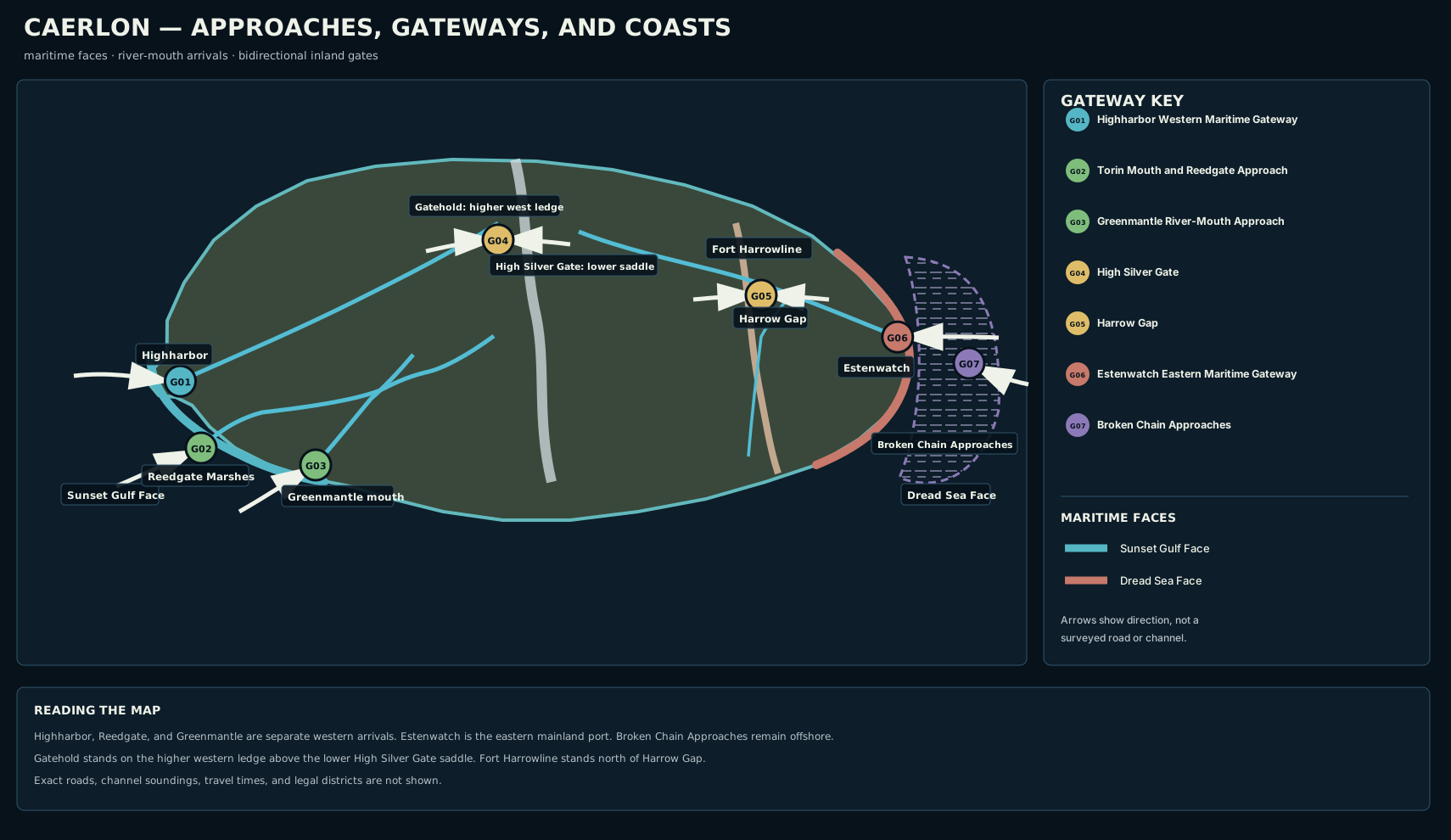
Caerlon’s principal maritime faces and geographic gateways. Arrows show approach direction rather than a surveyed route or measured travel time.
Open the full gateway map · Read the gateway-map description

Gateway Summary
| Gateway | Form | Ordinary receiver | First public arrival |
|---|---|---|---|
| Highharbor Western Maritime Gateway | Deep estuary and major port | Pilot crew, signal guilds, customs blocs, and dock watch | Assigned quay, passenger court, or Saltwatch waiting quay |
| Torin Mouth and Reedgate Approach | Shallow tidal marsh channels | Reedgate channel guide and Torin Bridge Wardens | Reedgate lower landing and raised marsh road |
| Greenmantle River-Mouth Approach | Sheltered shallow inlet | A named communal, estate, or village landing keeper | The landing arranged by the traveler’s host |
| High Silver Gate | Mountain and watershed pass | Silveredge pass keeper and hold watch | Western receiving terrace or eastern shelter ground, depending on direction |
| Harrow Gap | River road through a defensive ridge | Harrow Gap watch beneath Fort Harrowline | Marcher or Estenmark approach ground beyond the narrowing |
| Estenwatch Eastern Maritime Gateway | Fortified estuary port | Estenwatch pilot, Broken Chain Wardens, and Marcher watch | Lower inspection-quay court and public river road |
| Broken Chain Approaches | Reefs, islets, waiting anchorages, and controlled channels | Broken Chain boarding warden and patrol escort | Assigned quarantine islet, inspection anchorage, or escorted Estenwatch route |
Public Signals
The signal forms are deliberately different. A traveler should identify the place as well as the color or shape. A signal seen in the wrong geography is not trusted.
| Gateway | Open or acknowledged | Restricted or waiting | Closed or denied |
|---|---|---|---|
| Highharbor | White above blue | Amber above white; hold for pilot | Paired red on both headlands |
| Reedgate | White bar in the west, middle, or east channel position | Amber bar; guide required | Black cross across all three positions |
| Greenmantle | Agreed white-and-green landing board | Red diagonal; wait for a host boat | No agreed board or an inverted board |
| High Silver Gate | White ring on the relevant approach | Amber half-ring; escorted or limited passage | Black cross-board |
| Harrow Gap | White shield on Fort Harrowline | Red shield; inspection or convoy direction | Black shield and road crossbar |
| Estenwatch | Two white lights vertically | Amber over white; wait for pilot or inspection | Three red lights vertically |
| Broken Chain | White-blue-white acknowledges and assigns waiting | Moving blue escort lantern; follow the patrol | Red-white-red; withdraw beyond the outer line |
The Sunset Gulf Face
The Sunset Gulf Face includes three distinct river-to-sea entrances. They do not form one harbor system. Highharbor can receive the largest vessels. Reedgate exchanges deep water for marsh access. Greenmantle provides a sheltered regional arrival without a single public port authority.
Highharbor Western Maritime Gateway
Highharbor stands on both banks of the Valen estuary. The older city and principal shipyards occupy the downstream right-bank headland, while lower quays and warehouses occupy the opposite flats. The deep central channel supports ocean-going traffic; shallow side water serves local craft. Valen outflow is strongest after mountain rain, and an ebb tide increases the outward set. Estuary flats and a shifting outer bar, rather than reefs, are the main fixed water hazards.
Unfamiliar or deep-draft vessels take a pilot outside the headlands. The pilot assigns the channel and tells the vessel whether it will berth, wait inside, remain outside, or move to Saltwatch. A vessel denied city entry does not choose another quay for itself.
| Approach fact | Public condition |
|---|---|
| Origin and direction | Sunset Gulf; west to east |
| First landmark | Highharbor |
| Waiting place | Outer waiting water west of the estuary headlands |
| Arrival | Assigned quay apron, passenger court, or Saltwatch waiting quay |
| Receiver | Highharbor pilot crew, Highharbor intake clerk |
| Denied or closed | Remain at the outer waiting line, accept diversion to Saltwatch, or withdraw west when ordered. |
| Current and tide | Valen outflow is strongest in the central channel and after spring rain. Rising or early high tide gives deep-draft vessels the broadest margin; ebb tide strengthens the outward set. |
| Shoals or reefs | Estuary flats and a shifting outer bar flank the central channel; reefs are not the ordinary hazard. |
| Usable depth | deep central channel for ocean-going vessels; shallower side water for local craft |
| Wind and visibility | Sunset Gulf westerlies and crosswinds; estuary fog is common. |
| Pilot or guide | Unfamiliar or deep-draft vessels take a Highharbor pilot outside the headlands. |
Ordinary Highharbor Arrival
- Vessel crew: Sight the Valen opening and both Highharbor headlands.
- Master or signaler: Answer the pilot hail and display identity.
- Pilot crew: Boards outside the headlands and confirms channel, tide, and berth.
- Vessel crew: Follows the central channel or assigned side water.
- Harbor watch: Directs the vessel to a quay, passenger court, or Saltwatch waiting berth.
- Intake clerk: Records origin, cargo category, passengers, distress, and restrictions.
- Travelers: Enter the assigned public quay area and continue into Highharbor or the lower Valen.
Torin Mouth and Reedgate Approach
The Torin reaches the gulf south of Highharbor through Reedgate Marshes. Below Reedgate Hold, the river divides into western, middle, and eastern tidal branches. The Hold’s channel board identifies which branches are usable. A white bar marks an open branch; an amber bar requires a guide; a black cross closes the mouth.
The western branch normally carries the greatest depth but is most exposed to tide. The middle branch is shorter and changes fastest after flood or channel work. The eastern branch is narrower and most familiar to local riverboats. These are functional descriptions, not permanent guarantees. A guide chooses the branch based on current conditions.
| Approach fact | Public condition |
|---|---|
| Origin and direction | Sunset Gulf; southwest to northeast |
| First landmark | Reedgate Hold |
| Waiting place | Marked outer reedline below the three channel mouths |
| Arrival | Reedgate lower landing and raised marsh road |
| Receiver | Reedgate channel guide |
| Denied or closed | Wait outside the reedline, transfer to a local lighter if offered, or return to Highharbor. |
| Current and tide | River flow and tidal backwater change which branch carries the safest current. Rising water favors inward passage; ebb exposes mud and increases outward pull. |
| Shoals or reefs | Mudflats, reed islands, submerged embankments, and dead-end side water replace reef hazards. |
| Usable depth | shallow-draft coastal craft and riverboats; deep-draft vessels remain outside and lighter cargo |
| Wind and visibility | Sheltered from open gulf wind but vulnerable to fog and crosswind over reed channels. |
| Pilot or guide | Nonlocal crews take a Reedgate channel guide; locals follow the current Hold board. |
Ordinary Reedgate Arrival
- Vessel crew: Sight the Reedgate board and the raised Hold above the marsh.
- Master: Reads the west, middle, and east channel positions.
- Channel guide: Boards a nonlocal craft and selects the marked usable branch.
- Vessel crew: Passes mudflats, reed islands, and old embankments without leaving the chosen branch.
- Bridge Warden: Receives the craft at the lower Hold landing.
- Bridge Warden: Records destination and the next Bridgehold expected upriver.
- Travelers: Enter the raised marsh road or continue upriver toward Lowspan.
Greenmantle River-Mouth Approach
The Greenmantle reaches a sheltered inlet southeast of the Torin mouth. The approach is suitable for small coastal craft, riverboats, fishing vessels, and lighters. A shallow mouth bar limits deep-draft entry, and hill runoff can create a short, strong outward current even when the inlet itself remains calm.
Greenmantle has no single shared harbor office or universal public quay. Ordinary arrival is arranged with a communal landing, village landing, or estate stair. A white-and-green board identifies the receiving landing described in the agreement. A vessel without a host or recognized public landing waits outside the mouth or diverts. The water feature remains the Greenmantle River Mouth; the separate landing is the place of reception.
| Approach fact | Public condition |
|---|---|
| Origin and direction | Sunset Gulf; southwest to northeast |
| First landmark | Verdant Court of Returning Heirs |
| Waiting place | Sheltered water outside the mouth marker |
| Arrival | The receiving communal landing, estate stair, or village landing named by the host |
| Receiver | Greenmantle landing keeper |
| Denied or closed | Remain outside the mouth, seek a different host, or divert to Reedgate or Highharbor. |
| Current and tide | Normally gentle in the sheltered mouth; hill runoff can create a short, strong outward current. Tide affects the shallow mouth bar and landing stairs more than the protected inner water. |
| Shoals or reefs | A shallow sand-and-mud bar and vegetated banks are the ordinary hazards; no open reef field is established. |
| Usable depth | small coastal craft, riverboats, fishing boats, and lighters |
| Wind and visibility | Sheltered from the strongest gulf wind; humid fog can remain after the outer coast clears. |
| Pilot or guide | No universal pilot office; unfamiliar crews arrange a local guide or host before entering. |
Ordinary Greenmantle Arrival
- Vessel crew: Sight the sheltered indentation and descending Verdant terraces.
- Master: Finds the agreed white-and-green landing board.
- Host boat or guide: Meets the vessel outside the shallow mouth bar.
- Vessel crew: Enters on suitable water or transfers passengers and cargo to a lighter.
- Landing keeper: Receives the party at the named communal, estate, or village landing.
- Host or keeper: Confirms destination and the inland estate or river road.
- Travelers: Enter the receiving landing and continue through the Greenmantle valley.
The Inland Gateways
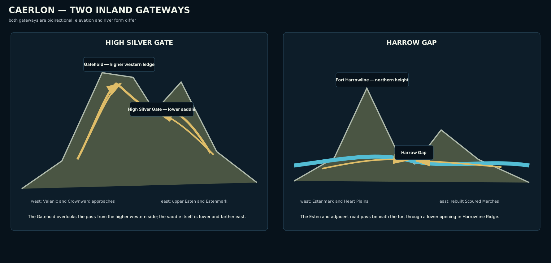
High Silver Gate crosses a watershed saddle below the higher western Gatehold ledge. Harrow Gap follows the Esten through a lower defensive ridge beneath Fort Harrowline.
Open the inland-gateway comparison · Read the comparison description

High Silver Gate
Silveredge Gatehold stands on the western and higher ledge above the pass. High Silver Gate is the lower saddle east of that ledge. Travelers approaching from the west see Gatehold first, report at the receiving terrace below it, and then move down or laterally toward the saddle. Travelers approaching from the east reach the pass saddle first and then continue toward the higher Gatehold side.
The pass boards on both approaches use the same white-ring, amber-half-ring, and black-cross system. The keeper records party size, pack animals, destination, and declared hazardous loads. Snow, ice, high wind, poor visibility, unstable slopes, or falling stone can close the crossing even when lower country remains clear.
West to East
- Travelers: Sight the Gatehold on the higher western ledge.
- Party leader: Reads the western ring board and reports at the receiving terrace.
- Pass keeper: Counts travelers, pack animals, and declared hazardous loads.
- Travelers: Move from the higher western Gatehold side down or across to the lower pass saddle.
- Pass keeper: Releases the party through the saddle in the assigned order.
- Travelers: Descend toward the upper Esten and Eastfall side.
- Travelers: Enter Estenmark or turn toward the northern Heart Plains.
East to West
From Estenmark, travelers sight the lower saddle before the Gatehold ledge. They wait on eastern shelter ground when the board is closed or unreadable, cross the saddle when released, and then climb toward the western receiving terrace. Denied travelers remain east or descend toward Estenmark; there is no equal nearby continent-scale crossing.
Harrow Gap
Harrow Gap carries the Esten through Harrowline Ridge. Fort Harrowline stands on the northern height above the narrowing. The gap is lower and broader than High Silver Gate, and ordinary traffic can pass without a full inspection when the white shield is displayed. Red requires inspection or convoy direction. Black closes the road and river crossing.
West to East
- Travelers: Sight Fort Harrowline on the northern height above the Esten.
- Party leader: Reads the white, red, or black shield panel.
- Gap watch: Inspects only when alert, convoy, salvage, arms, or contamination rules require it.
- Travelers: Follow the river road as ridge and river narrow together.
- Gap watch: Releases the party beneath the fort’s observation.
- Travelers: Pass the Harrowline transition into the rebuilt western Marches.
- Travelers: Continue toward Bellweather country and the lower Esten.
East to West
Travelers from the Marches sight the same fort from the opposite side. They wait on the eastern Marcher ground, submit salvaged arms, contaminated loads, escorted returnees, or large convoys for inspection during alerts, and pass west into Estenmark when released. Denied traffic remains on the Marcher side or returns toward Bellweather country.
The Dread Sea Face
The Dread Sea Face includes the physical eastern coast, the Esten estuary at Estenwatch, and the offshore Broken Chain Approaches. Estenwatch is a mainland fortress-port. The Approaches are a distributed control zone and cannot be bypassed by choosing an unmarked channel.
Estenwatch Eastern Maritime Gateway
Estenwatch occupies the downstream right-bank headland at the Esten mouth, on the southern side of the east-flowing river. The recognized deep channel lies beneath that headland. Low shoals flank it. River outflow and onshore wind can oppose one another, producing steep, confused water at the mouth.
Unfamiliar or deep-draft vessels take an Estenwatch pilot outside the estuary. The pilot confirms tide, outflow, shoals, and inspection status. The ordinary receiving place is the lower inspection quay beneath the headland. A vessel without landing space remains in seaward waiting water or moves to an assigned quarantine station.
| Approach fact | Public condition |
|---|---|
| Origin and direction | Dread Sea; east to west |
| First landmark | Estenwatch |
| Waiting place | Seaward waiting water east of the right-bank headland |
| Arrival | Lower inspection-quay court and public river road |
| Receiver | Estenwatch pilot |
| Denied or closed | Hold seaward if safe, accept transfer to a quarantine station, or withdraw into open Dread Sea water. |
| Current and tide | Esten outflow runs east; onshore wind and rising tide can oppose it and create steep water at the mouth. Rising tide eases entry for deeper craft; ebb strengthens the outward river set. |
| Shoals or reefs | Low shoals flank the recognized estuary channel; the right-bank headland gives the clearest landmark. |
| Usable depth | deep recognized channel for sea-going vessels; low side water remains hazardous |
| Wind and visibility | Dread Sea onshore wind, squalls, fog, and autumn or winter gales. |
| Pilot or guide | Unfamiliar or deep-draft vessels take an Estenwatch pilot outside the mouth. |
Ordinary Estenwatch Arrival
- Vessel crew: Sight the Esten opening and the right-bank Estenwatch headland.
- Master or signaler: Answers the headland hail and reads the vertical mast signal.
- Estenwatch pilot: Boards outside the mouth and confirms tide, river outflow, shoals, and inspection status.
- Vessel crew: Follows the recognized channel beneath the right-bank headland.
- Marcher or Warden watch: Receives the vessel at the inspection quay or assigned quarantine station.
- Intake watch: Records route, origin, passengers, prisoners, contamination, distress, and hazardous cargo.
- Travelers: Enter the lower quay court and public river road into the Scoured Marches.
Broken Chain Approaches
The Broken Chain Approaches begin beyond the mainland coast. Reefs, shoals, wrecks, narrow channels, quarantine islets, patrol anchorages, and warning stations make this a controlled approach zone rather than one harbor. There is no general “safe depth” across the region. Clearance applies to an assigned channel and current conditions.
Unfamiliar or foreign vessels stop at the outer signal and accept Warden pilotage or patrol escort. The first legal arrival is an assigned anchorage or quarantine islet, not an unmarked mainland beach. White-blue-white acknowledges the vessel and assigns waiting. A moving blue lantern means follow the escort. Red-white-red means withdraw. An unlit station is treated as closed.
| Approach fact | Public condition |
|---|---|
| Origin and direction | Dread Sea, Broken Chain; east or offshore to west |
| First landmark | Broken Chain Quarantine Islets |
| Waiting place | Assigned outer anchorage beyond the first warning line |
| Arrival | Assigned quarantine islet, inspection anchorage, or escorted Estenwatch landing |
| Receiver | Broken Chain boarding warden |
| Denied or closed | Remain held, accept emergency quarantine, or follow escort back beyond the outer warning line; there is no lawful bypass. |
| Current and tide | Cross-currents move between islets and reef passages; a safe set in one channel does not describe the next. Tide changes reef clearance and the direction of narrow-channel flow. |
| Shoals or reefs | Reefs, shoals, wrecks, and false-looking passages are defining hazards. |
| Usable depth | channel-specific; no general safe depth applies across the Approaches |
| Wind and visibility | Dread Sea gales, sudden squalls, and lee turbulence around islets. |
| Pilot or guide | Unfamiliar or foreign vessels accept Warden pilotage or patrol escort; current local clearance may permit escorted small craft. |
Ordinary Broken Chain Arrival
- Vessel crew: Sight the first Warden station or quarantine-islet warning line.
- Master: Stops and answers the white-blue-white acknowledgement signal.
- Boarding warden: Assigns an outer anchorage and checks route token, chart authority, passengers, prisoners, and contamination.
- Pilot or patrol escort: Leads the vessel through the assigned channel without leaving the wake line.
- Warden station: Directs the vessel to a quarantine islet, inspection anchorage, or escorted Estenwatch route.
- Boarding warden: Issues release, continued quarantine, or red-white-red withdrawal.
- Travelers: Enter the assigned controlled public area or continue under escort to Estenwatch.
Comparing Water Arrivals
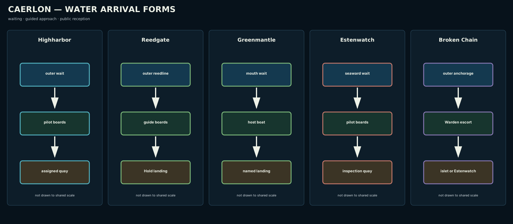
The panels compare approach form. They do not share a measured scale.
Open the water-arrival comparison · Read the comparison description

Gateway Sequences
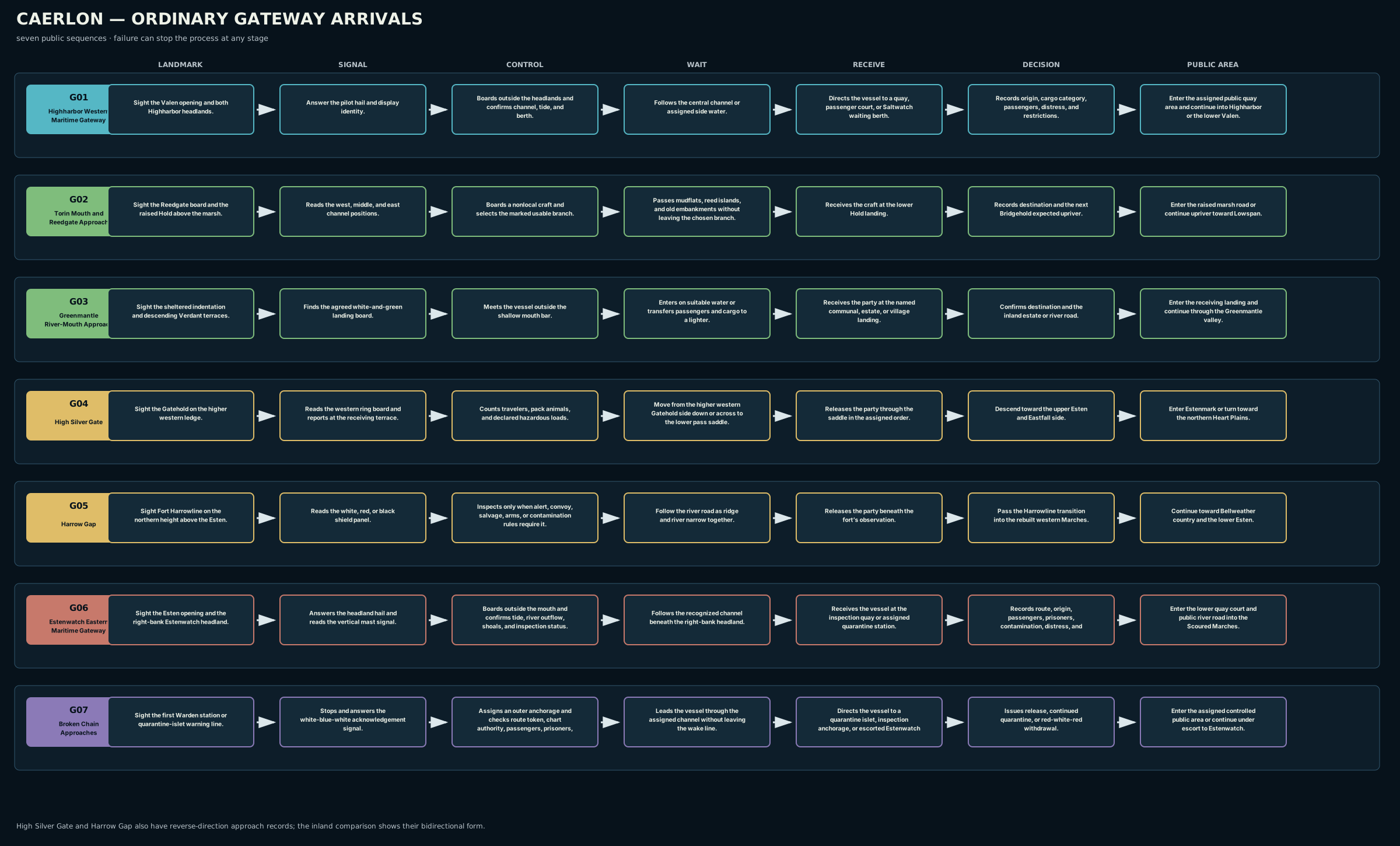
The sequence diagram records ordinary public order. Weather, danger, quarantine, or closure can stop the sequence at any stage.
Open the gateway-sequence diagram · Read the sequence description

Gateways in Play
A gateway name does not impose one automatic game effect. The actual scene determines the mechanic. Pathfinder Second Edition Remaster can represent these approaches through aquatic environments, currents, difficult terrain, uneven ground, the Climb and Balance actions, concealment, environmental cold, strong wind, and local hazards. A pilot or guide can provide information or reduce uncertainty without removing the danger of a failed check.
The local map determines the DC, distance, action, and consequence. The continent map establishes where the gateway sits, what travelers can recognize, where they wait, and what ordinary public sequence they attempt.
Map Scope
This page establishes the seven principal approach systems, their ordinary public signals, qualitative maritime conditions, waiting points, receivers, denial results, first public areas, and both directions through High Silver Gate and Harrow Gap. It does not assign measured travel time, exact road alignment, numerical channel soundings, detailed harbor districts, comprehensive laws, military command structures, or hidden routes.
← Regions, Boundaries, and Adjacency · Caerlon — Geography and Maps